Difference between revisions of "2013-05-02 66 25"
From Geohashing
imported>Isopekka |
imported>FippeBot m (Location) |
||
| Line 80: | Line 80: | ||
[[Category:Expeditions with photos]] | [[Category:Expeditions with photos]] | ||
[[Category:Coordinates reached]] | [[Category:Coordinates reached]] | ||
| + | {{location|FI|10}} | ||
Latest revision as of 02:09, 14 August 2019
| Thu 2 May 2013 in 66,25: 66.4326496, 25.7674812 geohashing.info google osm bing/os kml crox |
Contents
Location
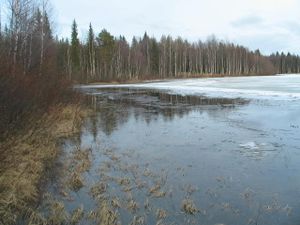
In Kursunki, near the lake Kursunki, about 7 km from my home.
Participants
- isopekka, wife,dog
Expedition
- Driving total15 km
- Walking total 0.5 km
- Expedition took 1.0 h
- Physical effort (1-5): 1
Expedition started about at 6:15 p.m. The Hashpoint situated in the forest (surprise!), about 200 meters from the road. Distance from the Hash to the lake Kursunki was only 50 m. Nice evening walk.
Photos
Achievements
isopekka earned the Land geohash achievement
|
isopekka earned the Consecutive geohash achievement
|
Geohashing Expeditions and Plans on This Day
Expeditions and Plans
| 2013-05-02 | ||
|---|---|---|
| Singapore, Singapore | vermouthandgin | On the street in Woodlands Industrial Park |
| Moscow, Russia | vb | Domodedovo (town), Kashira Hwy, on the sidewalk. |
| Rovaniemi, Finland | isopekka, dog | In Kursunki, near the lake Kursunki, about 7 km from my home. |


