Difference between revisions of "2013-05-11 35 -79"
imported>Birdray (Replaced content with "{{subst:Expedition |lat = 35 |lon = -79 |date = 2013-05-11 }}") |
imported>Birdray |
||
| Line 1: | Line 1: | ||
| + | [[Image:{{{image|2013-05-11_35_-79_1.jpg}}}|thumb|left]] | ||
| − | |||
| − | |||
| − | |||
| − | |||
| − | |||
| − | |||
| − | |||
| − | |||
| − | |||
{{meetup graticule | {{meetup graticule | ||
| lat=35 | | lat=35 | ||
| Line 15: | Line 7: | ||
}} | }} | ||
| − | |||
__NOTOC__ | __NOTOC__ | ||
== Location == | == Location == | ||
| − | + | Appears to be just off a road in a subdivision still under construction. | |
== Participants == | == Participants == | ||
| − | + | [[User:Birdray|Birdray]] ([[User talk:Birdray|talk]]) | |
| − | |||
== Plans == | == Plans == | ||
| − | + | I was going to be in town for the day, and planned to detour to the hashpoint on my way back out. | |
== Expedition == | == Expedition == | ||
| − | + | As I headed out to the hashpoint it was pouring, which wasn't promising. I drove into the neighborhood--which was, as it originally appeared to be--a subdivision still under construction. It was actually a little eerie; the roads were all completed, with grand landscaping throughout and no signs of construction, but I saw maybe two houses total. | |
| + | |||
| + | I drove by the point with another car behind me, and too little room on the road to pull over, so I looped around and parked on an intersecting road, then got out of my car and walked. The rain had let up a little and I had my umbrella (No Drowned Rat achievement for me, thankfully). The point turned out to be just off the sidewalk toward the woods; my app said I was as close to the point as it could accurately tell, but I tried to get as close as possible by the meter count, and ended up pushing into the woods a little bit while cars drove by behind me. (Don't mind me, I'm just poking around in the woods in a half-abandoned upscale subdivision here.) | ||
== Tracklog == | == Tracklog == | ||
| − | + | [http://www.everytrail.com/view_trip.php?trip_id=2128133 My tracklog on EveryTrail] | |
== Photos == | == Photos == | ||
| − | |||
| − | |||
| − | |||
<gallery perrow="5"> | <gallery perrow="5"> | ||
| + | Image:2013-05-11_35_-79_1.jpg | My general impression of the weather at the hashpoint. | ||
| + | Image:2013-05-11_35_-79_2.jpg | Point reached! | ||
</gallery> | </gallery> | ||
== Achievements == | == Achievements == | ||
{{#vardefine:ribbonwidth|800px}} | {{#vardefine:ribbonwidth|800px}} | ||
| − | + | {{land geohash | |
| − | + | | latitude = 35 | |
| + | | longitude = -79 | ||
| + | | date = 2013-05-11 | ||
| + | | name = [[User:Birdray|Birdray]] | ||
| + | | image = 2013-05-11_35_-79_1.jpg | ||
| + | }} | ||
| − | |||
| − | |||
[[Category:New report]] | [[Category:New report]] | ||
| − | |||
| − | |||
| − | |||
| − | |||
| − | |||
| − | |||
| − | |||
[[Category:Expeditions]] | [[Category:Expeditions]] | ||
| − | |||
[[Category:Expeditions with photos]] | [[Category:Expeditions with photos]] | ||
| − | |||
| − | |||
| − | |||
| − | |||
| − | |||
[[Category:Coordinates reached]] | [[Category:Coordinates reached]] | ||
| − | |||
| − | |||
| − | |||
| − | |||
| − | |||
| − | |||
| − | |||
| − | |||
| − | |||
| − | |||
| − | |||
| − | |||
| − | |||
| − | |||
| − | |||
| − | |||
| − | |||
| − | |||
Revision as of 03:43, 12 May 2013

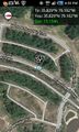
| Sat 11 May 2013 in 35,-79: 35.8291249, -79.1022332 geohashing.info google osm bing/os kml crox |
Location
Appears to be just off a road in a subdivision still under construction.
Participants
Plans
I was going to be in town for the day, and planned to detour to the hashpoint on my way back out.
Expedition
As I headed out to the hashpoint it was pouring, which wasn't promising. I drove into the neighborhood--which was, as it originally appeared to be--a subdivision still under construction. It was actually a little eerie; the roads were all completed, with grand landscaping throughout and no signs of construction, but I saw maybe two houses total.
I drove by the point with another car behind me, and too little room on the road to pull over, so I looped around and parked on an intersecting road, then got out of my car and walked. The rain had let up a little and I had my umbrella (No Drowned Rat achievement for me, thankfully). The point turned out to be just off the sidewalk toward the woods; my app said I was as close to the point as it could accurately tell, but I tried to get as close as possible by the meter count, and ended up pushing into the woods a little bit while cars drove by behind me. (Don't mind me, I'm just poking around in the woods in a half-abandoned upscale subdivision here.)
Tracklog
Photos

My general impression of the weather at the hashpoint.
Point reached!

Achievements
Birdray earned the Land geohash achievement
|