Difference between revisions of "2013-05-13 43 -116"
imported>Eldin ([live picture] Marker [http://www.openstreetmap.org/?lat=43.57220000&lon=-116.03900000&zoom=16&layers=B000FTF @43.5722,-116.0390]) |
imported>Eldin (Fill in expedition details and add more pictures.) |
||
| Line 1: | Line 1: | ||
| − | + | [[Image:{{{image|2013-05-13 43 -116 towards hashpoint.jpg}}}|thumb|left]] | |
| − | |||
| − | |||
| − | [[Image:{{{image| | ||
| − | |||
| − | |||
| − | |||
| − | |||
| − | |||
| − | |||
{{meetup graticule | {{meetup graticule | ||
| lat=43 | | lat=43 | ||
| Line 15: | Line 6: | ||
}} | }} | ||
| − | |||
__NOTOC__ | __NOTOC__ | ||
== Location == | == Location == | ||
| − | + | ||
| + | In the hills NW of Lucky Peak Reservoir. | ||
== Participants == | == Participants == | ||
| − | + | ||
| − | + | *[[User:Eldin|Eldin]] | |
== Plans == | == Plans == | ||
| − | + | ||
| + | It was a beautiful day, and the hash wasn't too far out of town. So I planned to try to reach it after work. | ||
| + | |||
== Expedition == | == Expedition == | ||
| − | + | ||
| + | I got off work a bit after 5pm, and set out towards the hash point. I had identified a trail near the hash which had a flat space for parking by the road from satellite imagery. The drive up to the spot where I parked was uneventful. While it was about 90°F in town, at this higher elevation the thermometer in my car was reading 78°F, so it was warm, but not too hot. It was a sunny day with a light breeze. Wildflowers were blooming all over. There was a nice trail (looks like it used to be a jeep trail, but a sign at the base prohibits motor vehicles now) which went about half way to the hash before turning and going the wrong direction. And even after leaving the trail, most of the vegetation was short grass and widely scattered sagebrush and bitter brush, so the going was fairly easy. The terrain was a bit steep in places, but mostly not too bad. I passed post lines of several former fences, but none of them had wire up anymore. It only took about 15 minutes to reach the hash point. I left a crude marker crafted from sticks found near the spot. Maybe if someone finds it they'll be curious enough about what 'XKCD' means to google it. I only had about 50m of total elevation gain on my hike, though it felt like more when I was doing it. The walk back went quicker than the walk up, on account of it being mostly down hill, though I did stop once I found a data signal again to post news of my success here. | ||
*Hash point reached. This is the nearest I could get a data signal. -- [[User:Eldin|Eldin]] ([[User talk:Eldin|talk]]) [http://www.openstreetmap.org/?lat=43.57181998&lon=-116.03907342&zoom=16&layers=B000FTF @43.5718,-116.0391] 19:10, 13 May 2013 (MDT) | *Hash point reached. This is the nearest I could get a data signal. -- [[User:Eldin|Eldin]] ([[User talk:Eldin|talk]]) [http://www.openstreetmap.org/?lat=43.57181998&lon=-116.03907342&zoom=16&layers=B000FTF @43.5718,-116.0391] 19:10, 13 May 2013 (MDT) | ||
| + | |||
== Tracklog == | == Tracklog == | ||
| − | + | Tracklog will be posted later. | |
== Photos == | == Photos == | ||
| − | |||
| − | |||
| − | |||
<gallery perrow="5"> | <gallery perrow="5"> | ||
| Line 44: | Line 36: | ||
Image:2013-05-13_43_-116_19-11-44-158.jpg | Marker [http://www.openstreetmap.org/?lat=43.57220000&lon=-116.03900000&zoom=16&layers=B000FTF @43.5722,-116.0390] | Image:2013-05-13_43_-116_19-11-44-158.jpg | Marker [http://www.openstreetmap.org/?lat=43.57220000&lon=-116.03900000&zoom=16&layers=B000FTF @43.5722,-116.0390] | ||
| + | |||
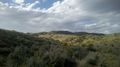
| + | Image:2013-05-13 43 -116 towards hashpoint.jpg | Looking towards the hashpoint from near where I parked. | ||
| + | |||
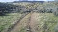
| + | Image:2013-05-13 43 -116 trail.jpg | This trail got me about half way there. | ||
| + | |||
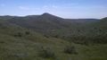
| + | Image:2013-05-13 43 -116 towards road.jpg | Looking back towards the road from the hash. | ||
| + | |||
| + | Image:2013-05-13 43 -116 flowers.jpg | Wild flowers growing along the trail I took. | ||
</gallery> | </gallery> | ||
== Achievements == | == Achievements == | ||
{{#vardefine:ribbonwidth|800px}} | {{#vardefine:ribbonwidth|800px}} | ||
| − | + | {{land geohash | |
| + | | latitude = 43 | ||
| + | | longitude = -116 | ||
| + | | date = 2013-05-13 | ||
| + | | name = [[User:Eldin|Eldin]] | ||
| + | }} | ||
| − | |||
| − | |||
| − | |||
| − | |||
| − | |||
| − | |||
| − | |||
| − | |||
| − | |||
| − | |||
| − | |||
[[Category:Expeditions]] | [[Category:Expeditions]] | ||
| − | |||
[[Category:Expeditions with photos]] | [[Category:Expeditions with photos]] | ||
| − | |||
| − | |||
| − | |||
| − | |||
| − | |||
[[Category:Coordinates reached]] | [[Category:Coordinates reached]] | ||
| − | |||
| − | |||
| − | |||
| − | |||
| − | |||
| − | |||
| − | |||
| − | |||
| − | |||
| − | |||
| − | |||
| − | |||
| − | |||
| − | |||
| − | |||
| − | |||
| − | |||
| − | |||
Revision as of 10:30, 16 May 2013

| Mon 13 May 2013 in 43,-116: 43.5722309, -116.0394874 geohashing.info google osm bing/os kml crox |
Location
In the hills NW of Lucky Peak Reservoir.
Participants
Plans
It was a beautiful day, and the hash wasn't too far out of town. So I planned to try to reach it after work.
Expedition
I got off work a bit after 5pm, and set out towards the hash point. I had identified a trail near the hash which had a flat space for parking by the road from satellite imagery. The drive up to the spot where I parked was uneventful. While it was about 90°F in town, at this higher elevation the thermometer in my car was reading 78°F, so it was warm, but not too hot. It was a sunny day with a light breeze. Wildflowers were blooming all over. There was a nice trail (looks like it used to be a jeep trail, but a sign at the base prohibits motor vehicles now) which went about half way to the hash before turning and going the wrong direction. And even after leaving the trail, most of the vegetation was short grass and widely scattered sagebrush and bitter brush, so the going was fairly easy. The terrain was a bit steep in places, but mostly not too bad. I passed post lines of several former fences, but none of them had wire up anymore. It only took about 15 minutes to reach the hash point. I left a crude marker crafted from sticks found near the spot. Maybe if someone finds it they'll be curious enough about what 'XKCD' means to google it. I only had about 50m of total elevation gain on my hike, though it felt like more when I was doing it. The walk back went quicker than the walk up, on account of it being mostly down hill, though I did stop once I found a data signal again to post news of my success here.
- Hash point reached. This is the nearest I could get a data signal. -- Eldin (talk) @43.5718,-116.0391 19:10, 13 May 2013 (MDT)
Tracklog
Tracklog will be posted later.
Photos

Grin @43.5722,-116.0390
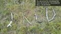
Marker @43.5722,-116.0390
Looking towards the hashpoint from near where I parked.
This trail got me about half way there.
Looking back towards the road from the hash.
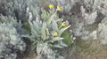
Wild flowers growing along the trail I took.


Achievements
Eldin earned the Land geohash achievement
|