Difference between revisions of "2013-05-15 47 -122"
From Geohashing
imported>Thomcat ([live picture] Spud! [http://www.openstreetmap.org/?lat=47.67843604&lon=-122.32701447&zoom=16&layers=B000FTF @47.6784,-122.3270]) |
imported>Thomcat ([live picture] No trespass, natch [http://www.openstreetmap.org/?lat=47.68270643&lon=-122.31204922&zoom=16&layers=B000FTF @47.6827,-122.3120]) |
||
| Line 30: | Line 30: | ||
Image:2013-05-15_47_-122_12-08-23-741.jpg | Spud! [http://www.openstreetmap.org/?lat=47.67843604&lon=-122.32701447&zoom=16&layers=B000FTF @47.6784,-122.3270] | Image:2013-05-15_47_-122_12-08-23-741.jpg | Spud! [http://www.openstreetmap.org/?lat=47.67843604&lon=-122.32701447&zoom=16&layers=B000FTF @47.6784,-122.3270] | ||
| + | |||
| + | Image:2013-05-15_47_-122_12-23-59-350.jpg | No trespass, natch [http://www.openstreetmap.org/?lat=47.68270643&lon=-122.31204922&zoom=16&layers=B000FTF @47.6827,-122.3120] | ||
</gallery> | </gallery> | ||
Revision as of 19:24, 15 May 2013
| Wed 15 May 2013 in Seattle: 47.6810543, -122.3124297 geohashing.info google osm bing/os kml crox |
Location
Inside the Roosevelt Reservoir in Seattle.
Participants
Plans
Likely no public access, but worth a lunchtime visit. Will visit after picking up Spud fish & chips.
Expedition
Tracklog
Photos
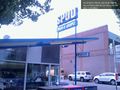
Spud! @47.6784,-122.3270
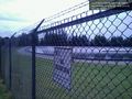
No trespass, natch @47.6827,-122.3120


Achievements