Difference between revisions of "2013-05-22 33 -116"
From Geohashing
imported>LucasBrown |
imported>Jiml m (Result codes look right) |
||
| Line 6: | Line 6: | ||
== Participants == | == Participants == | ||
| − | [[User:LucasBrown|LucasBrown]] | + | * [[User:LucasBrown|LucasBrown]] |
== Photos == | == Photos == | ||
| Line 15: | Line 15: | ||
</gallery> | </gallery> | ||
| − | + | == Achievements == | |
| + | |||
| + | * Land geohash | ||
| + | |||
[[Category:Expeditions]] | [[Category:Expeditions]] | ||
[[Category:Expeditions with photos]] | [[Category:Expeditions with photos]] | ||
[[Category:Expedition without GPS]] | [[Category:Expedition without GPS]] | ||
[[Category:Coordinates reached]] | [[Category:Coordinates reached]] | ||
Revision as of 12:25, 23 May 2013
| Wed 22 May 2013 in 33,-116: 33.0122519, -116.9546343 geohashing.info google osm bing/os kml crox |
Location
In the rough on the southeastern corner of the Mount Woodson Golf Club
Participants
Photos
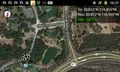
Map at the hashpoint
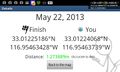
Geohash Droid details page at the hashpoint
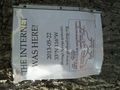
Sign deposited near the hashpoint


Achievements
- Land geohash