Difference between revisions of "2013-05-22 33 -96"
From Geohashing
imported>Neimster |
imported>FippeBot m (Location) |
||
| Line 30: | Line 30: | ||
[[Category:Expeditions with photos]] | [[Category:Expeditions with photos]] | ||
[[Category:Coordinates reached]] | [[Category:Coordinates reached]] | ||
| + | {{location|US|TX|DN}} | ||
Latest revision as of 02:28, 14 August 2019
| Wed 22 May 2013 in 33,-96: 33.0122519, -96.9546343 geohashing.info google osm bing/os kml crox |
Location
About 20 feet off the side of FM 3040 in Lewisville. 3040 is a fairly built up road, but this hash happened to be in a gap in the development near an overpass.
Participants
Expedition
Upon arriving in the area, I realized the only way to get to the location would be to park on the opposite side of the overpass. After venturing underneath it, I spotted a creek and decided it was probably a better idea to cross the bridge itself. The location was reached shortly afterward.
Photos
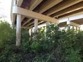
Not always a vile and wretched place.
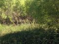
There's a creek hiding behind that grass. I guess I can't get through this way.

Time to turn back.
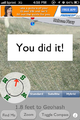
I did it.
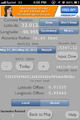
Proof.
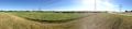
A quick panorama I took on my phone at the hash facing away from the road.


