Difference between revisions of "2013-06-03 48 11"
imported>Zertrin (coords reached) |
imported>Zertrin (report successful expedition) |
||
| Line 1: | Line 1: | ||
| − | |||
| − | |||
| − | |||
| − | |||
| − | |||
| − | |||
| − | |||
| − | |||
| − | |||
| − | |||
{{meetup graticule | {{meetup graticule | ||
| lat=48 | | lat=48 | ||
| Line 18: | Line 8: | ||
__NOTOC__ | __NOTOC__ | ||
== Location == | == Location == | ||
| − | + | 20 meters off a road through the forest between Germering and Gauting, just outside the limits of Munich. | |
== Participants == | == Participants == | ||
| − | + | [[User:Zertrin|Zertrin]] | |
| − | |||
== Plans == | == Plans == | ||
| − | + | Reach the point on my way back from work to home: it's only a little detour. | |
== Expedition == | == Expedition == | ||
| − | + | After the recently extremely rainy days, I was hesitating to attempt a hash in the forest, given that I didn't know if it would be extremely muddy or not, or if the weather by the end of the day would be kind enough to stop pouring shower amounts of rain. | |
| + | |||
| + | On the morning I took the usual geohasher's tools with me in case of. And at around 6 p.m. when I went out of my workplace, the rain had reverted to an acceptable level for geohasing purposes, and I decided to attempt this hash. | ||
| + | |||
| + | I drove uneventfully up to 150 meters from the hash, parked where I could, and entered the forest directly because I didn't want to walk along the quite narrow road where the cars drove quite fast. | ||
| + | |||
| + | By chance the forest was not dense, it seems it had been replanted years ago because the trees were aligned according to some pattern. The soil, albeit wet, wasn't muddy at all and quite hard, covered mostly by dead vegetation. | ||
| + | |||
| + | I reached the hashpoint easily, took the usual proofs, tried to make a panorama of it (failed, totally blurry so not shown...), and then headed back the same way to my car, and drove home. | ||
| + | |||
| + | Let's hope June will be a good month for hashes! | ||
== Tracklog == | == Tracklog == | ||
| − | + | Maybe later... | |
== Photos == | == Photos == | ||
| − | |||
| − | |||
| − | |||
<gallery perrow="5"> | <gallery perrow="5"> | ||
| + | Image:2013-06-03 48 11 - Zertrin - GPS coordinates.png | Coordinates reached! | ||
| + | Image:2013-06-03 48 11 - Zertrin at the hashpoint.JPG | Zertrin at the hashpoint | ||
</gallery> | </gallery> | ||
| Line 44: | Line 42: | ||
<!-- Add any achievement ribbons you earned below, or remove this section --> | <!-- Add any achievement ribbons you earned below, or remove this section --> | ||
| − | |||
| − | |||
| − | |||
| − | |||
| − | |||
| − | |||
| − | |||
| − | |||
| − | |||
| − | |||
| − | |||
[[Category:Expeditions]] | [[Category:Expeditions]] | ||
| − | |||
[[Category:Expeditions with photos]] | [[Category:Expeditions with photos]] | ||
| − | |||
| − | |||
| − | |||
| − | |||
| − | |||
[[Category:Coordinates reached]] | [[Category:Coordinates reached]] | ||
| − | |||
| − | |||
| − | |||
| − | |||
| − | |||
| − | |||
| − | |||
| − | |||
| − | |||
| − | |||
| − | |||
| − | |||
| − | |||
| − | |||
| − | |||
| − | |||
| − | |||
| − | |||
Revision as of 12:13, 4 June 2013
| Mon 3 Jun 2013 in 48,11: 48.0899115, 11.3535730 geohashing.info google osm bing/os kml crox |
Location
20 meters off a road through the forest between Germering and Gauting, just outside the limits of Munich.
Participants
Plans
Reach the point on my way back from work to home: it's only a little detour.
Expedition
After the recently extremely rainy days, I was hesitating to attempt a hash in the forest, given that I didn't know if it would be extremely muddy or not, or if the weather by the end of the day would be kind enough to stop pouring shower amounts of rain.
On the morning I took the usual geohasher's tools with me in case of. And at around 6 p.m. when I went out of my workplace, the rain had reverted to an acceptable level for geohasing purposes, and I decided to attempt this hash.
I drove uneventfully up to 150 meters from the hash, parked where I could, and entered the forest directly because I didn't want to walk along the quite narrow road where the cars drove quite fast.
By chance the forest was not dense, it seems it had been replanted years ago because the trees were aligned according to some pattern. The soil, albeit wet, wasn't muddy at all and quite hard, covered mostly by dead vegetation.
I reached the hashpoint easily, took the usual proofs, tried to make a panorama of it (failed, totally blurry so not shown...), and then headed back the same way to my car, and drove home.
Let's hope June will be a good month for hashes!
Tracklog
Maybe later...
Photos
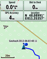
Coordinates reached!

Zertrin at the hashpoint

