Difference between revisions of "2013-06-06 43 -116"
imported>Eldin ([live] Made it! Details later.) |
imported>Eldin (Fill in expedition details.) |
||
| Line 1: | Line 1: | ||
| − | |||
| − | |||
| − | |||
| − | |||
| − | |||
| − | |||
| − | |||
| − | |||
| − | |||
| − | |||
{{meetup graticule | {{meetup graticule | ||
| lat=43 | | lat=43 | ||
| Line 15: | Line 5: | ||
}} | }} | ||
| − | |||
__NOTOC__ | __NOTOC__ | ||
== Location == | == Location == | ||
| − | + | In the foothills NE of Camel's Back park. | |
== Participants == | == Participants == | ||
| − | + | * [[User:Eldin|Eldin]] | |
| − | |||
== Plans == | == Plans == | ||
| − | + | When I saw that today's hash was only about 3 miles from my office, I decided to try for a walk geohash. | |
== Expedition == | == Expedition == | ||
| − | + | The expedition got off to a good start. I stopped in at a store near my office and purchased liquid refreshment for my walk. It was about 91ºF outside, but at this point there was plenty of shade and a breeze. | |
| + | The shade mostly vanished about a mile into the walk, at which point I began to regret not having brought a change of clothes with me to work, as it turns out that my work clothes aren't particularly well suited for long, hot walks. About 2 miles in, I realized I had seriously underestimated the amount of liquid refreshment I should have brought with me. About 2/3 of a mile from the hashpoint, the route started gaining elevation at a faster rate. About half a mile from the hashpoint, my beverage ran out. But by this time, I'd come too far to turn back just for being hot, tired, and thirsty. The last half hour went kind of slowly. But I eventually made it. Once there, I snapped some pictures and posted my success here. I was tired, but glad to have achieved my first Walk Geohash. The hash was within 80ft of the road that I walked in on, and there was a spot to park only about 250ft from the hash. And I'll admit there was a moment while I pondered the walk back to my office of wishing that I had driven. But the moment passed, and I set off to walk back down the hill. | ||
| + | Right as I got back to the road after reaching the hash, I startled myself by almost stepping on a roughly 40 inch snake. It gave me quite a scare when I first saw it, since this is rattlesnake country. But once I got a better look at it I realized it was just a mostly harmless gopher snake. Unfortunately, the snake had moved on by the time I thought to try to get a picture of it. The remainder of the walk back down the hill was largely uneventful, though kind of slow going, as I stopped several times to rest when I found a small patch of shade. Finally, exhausted and very thirsty, I made it back to where my car was parked, and after acquiring additional liquid refreshment, headed home. | ||
*I think I'm going to make it, but the last half mile is going to be rough. -- [[User:Eldin|Eldin]] ([[User talk:Eldin|talk]]) [http://www.openstreetmap.org/?lat=43.64610987&lon=-116.17930742&zoom=16&layers=B000FTF @43.6461,-116.1793] 18:52, 6 June 2013 (MDT) | *I think I'm going to make it, but the last half mile is going to be rough. -- [[User:Eldin|Eldin]] ([[User talk:Eldin|talk]]) [http://www.openstreetmap.org/?lat=43.64610987&lon=-116.17930742&zoom=16&layers=B000FTF @43.6461,-116.1793] 18:52, 6 June 2013 (MDT) | ||
*Made it! Details later. -- [[User:Eldin|Eldin]] ([[User talk:Eldin|talk]]) [http://www.openstreetmap.org/?lat=43.64758477&lon=-116.17135890&zoom=16&layers=B000FTF @43.6476,-116.1714] 19:27, 6 June 2013 (MDT) | *Made it! Details later. -- [[User:Eldin|Eldin]] ([[User talk:Eldin|talk]]) [http://www.openstreetmap.org/?lat=43.64758477&lon=-116.17135890&zoom=16&layers=B000FTF @43.6476,-116.1714] 19:27, 6 June 2013 (MDT) | ||
| + | |||
== Tracklog == | == Tracklog == | ||
| − | + | Partial tracklog, from a store near my office until I was on my way back from the hash, when I shut off the tracking to save on battery usage. | |
| + | |||
| + | http://goo.gl/maps/2Ihvn | ||
== Photos == | == Photos == | ||
| − | |||
| − | |||
| − | |||
<gallery perrow="5"> | <gallery perrow="5"> | ||
| + | File:2013-06-06 43 -116 hashpoint.jpg | The hash point. | ||
| + | File:2013-06-06 43 -116 grin.jpg | Something like a grin. | ||
| + | File:2013-06-06 43 -116 trees.jpg | Looking back towards Boise from up here, you can see why it's called the 'City of Trees'. | ||
| + | File:2013-06-06 43 -116 digitalis.jpg | Poison flowers growing along the road to the hashpoint. | ||
| + | |||
| + | |||
| + | |||
</gallery> | </gallery> | ||
== Achievements == | == Achievements == | ||
{{#vardefine:ribbonwidth|800px}} | {{#vardefine:ribbonwidth|800px}} | ||
| − | + | {{land geohash | latitude = 43 | longitude = -116 | date = 2013-06-06 | name = [[User:Eldin|Eldin]]}} | |
| − | + | {{Walk geohash | latitude = 43 | longitude = -116 | date = 2013-06-06 | name = [[User:Eldin|Eldin]] | distance = about 6.5 miles}} | |
| − | |||
| − | |||
| − | |||
| − | [[ | ||
| − | |||
| − | |||
| − | |||
| − | [[ | ||
| − | |||
| − | |||
[[Category:Expeditions]] | [[Category:Expeditions]] | ||
| − | |||
[[Category:Expeditions with photos]] | [[Category:Expeditions with photos]] | ||
| − | |||
| − | |||
| − | |||
| − | |||
| − | |||
[[Category:Coordinates reached]] | [[Category:Coordinates reached]] | ||
| − | |||
| − | |||
| − | |||
| − | |||
| − | |||
| − | |||
| − | |||
| − | |||
| − | |||
| − | |||
| − | |||
| − | |||
| − | |||
| − | |||
| − | |||
| − | |||
| − | |||
| − | |||
Revision as of 06:59, 11 June 2013
| Thu 6 Jun 2013 in 43,-116: 43.6475793, -116.1713534 geohashing.info google osm bing/os kml crox |
Location
In the foothills NE of Camel's Back park.
Participants
Plans
When I saw that today's hash was only about 3 miles from my office, I decided to try for a walk geohash.
Expedition
The expedition got off to a good start. I stopped in at a store near my office and purchased liquid refreshment for my walk. It was about 91ºF outside, but at this point there was plenty of shade and a breeze. The shade mostly vanished about a mile into the walk, at which point I began to regret not having brought a change of clothes with me to work, as it turns out that my work clothes aren't particularly well suited for long, hot walks. About 2 miles in, I realized I had seriously underestimated the amount of liquid refreshment I should have brought with me. About 2/3 of a mile from the hashpoint, the route started gaining elevation at a faster rate. About half a mile from the hashpoint, my beverage ran out. But by this time, I'd come too far to turn back just for being hot, tired, and thirsty. The last half hour went kind of slowly. But I eventually made it. Once there, I snapped some pictures and posted my success here. I was tired, but glad to have achieved my first Walk Geohash. The hash was within 80ft of the road that I walked in on, and there was a spot to park only about 250ft from the hash. And I'll admit there was a moment while I pondered the walk back to my office of wishing that I had driven. But the moment passed, and I set off to walk back down the hill.
Right as I got back to the road after reaching the hash, I startled myself by almost stepping on a roughly 40 inch snake. It gave me quite a scare when I first saw it, since this is rattlesnake country. But once I got a better look at it I realized it was just a mostly harmless gopher snake. Unfortunately, the snake had moved on by the time I thought to try to get a picture of it. The remainder of the walk back down the hill was largely uneventful, though kind of slow going, as I stopped several times to rest when I found a small patch of shade. Finally, exhausted and very thirsty, I made it back to where my car was parked, and after acquiring additional liquid refreshment, headed home.
- I think I'm going to make it, but the last half mile is going to be rough. -- Eldin (talk) @43.6461,-116.1793 18:52, 6 June 2013 (MDT)
- Made it! Details later. -- Eldin (talk) @43.6476,-116.1714 19:27, 6 June 2013 (MDT)
Tracklog
Partial tracklog, from a store near my office until I was on my way back from the hash, when I shut off the tracking to save on battery usage.
Photos
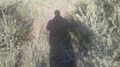
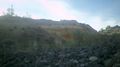
The hash point.

Something like a grin.
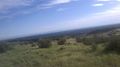
Looking back towards Boise from up here, you can see why it's called the 'City of Trees'.
Poison flowers growing along the road to the hashpoint.


Achievements
Eldin earned the Land geohash achievement
|
Eldin earned the Walk geohash Achievement
|