Difference between revisions of "2013-06-16 48 9"
From Geohashing
imported>Kobras (First geohash where the GPS battery didn't run flat near the final location. Don and me made it to the destination in an orchard of the lovely Erms valley. [http://www.openstreetmap.org/?lat=48.51050000&lon=9.35571000&zoom=16&layers=B000FTF @48.5105,9...) |
imported>Palmpje (Setting result codes and some implied info) |
||
| Line 19: | Line 19: | ||
== Location == | == Location == | ||
<!-- where you've surveyed the hash to be --> | <!-- where you've surveyed the hash to be --> | ||
| + | Near Dettingen an der Erms | ||
== Participants == | == Participants == | ||
<!-- who attended: If you link to your wiki user name in this section, your expedition will be picked up by the various statistics generated for geohashing. You may use three tildes ~ as a shortcut to automatically insert the user signature of the account you are editing with. | <!-- who attended: If you link to your wiki user name in this section, your expedition will be picked up by the various statistics generated for geohashing. You may use three tildes ~ as a shortcut to automatically insert the user signature of the account you are editing with. | ||
--> | --> | ||
| + | * [[User:Kobras|Kobras]] | ||
| + | * Don | ||
== Plans == | == Plans == | ||
| Line 29: | Line 32: | ||
== Expedition == | == Expedition == | ||
<!-- how it all turned out. your narrative goes here. --> | <!-- how it all turned out. your narrative goes here. --> | ||
| + | They made it! | ||
== Tracklog == | == Tracklog == | ||
| Line 46: | Line 50: | ||
<!-- Add any achievement ribbons you earned below, or remove this section --> | <!-- Add any achievement ribbons you earned below, or remove this section --> | ||
| − | |||
| − | |||
| − | |||
| − | |||
| − | |||
| − | |||
| − | |||
| − | |||
| − | |||
| − | |||
| − | |||
[[Category:Expeditions]] | [[Category:Expeditions]] | ||
| − | |||
[[Category:Expeditions with photos]] | [[Category:Expeditions with photos]] | ||
| − | |||
| − | |||
| − | |||
| − | |||
| − | |||
[[Category:Coordinates reached]] | [[Category:Coordinates reached]] | ||
| − | + | <!-- or if you failed :( | |
| − | |||
[[Category:Coordinates not reached]] | [[Category:Coordinates not reached]] | ||
-- and a reason -- | -- and a reason -- | ||
Revision as of 17:17, 17 June 2013
| Sun 16 Jun 2013 in 48,9: 48.5105090, 9.3556832 geohashing.info google osm bing/os kml crox |
Location
Near Dettingen an der Erms
Participants
- Kobras
- Don
Plans
Expedition
They made it!
Tracklog
Photos
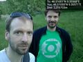
First geohash where the GPS battery didn't run flat near the final location. Don and me made it to the destination in an orchard of the lovely Erms valley. @48.5105,9.3557

Achievements