Difference between revisions of "2013-07-12 55 37"
From Geohashing
imported>Vb ([live] ~19km walk geohash: home - hash - Metro station) |
imported>Vb |
||
| Line 19: | Line 19: | ||
== Location == | == Location == | ||
<!-- where you've surveyed the hash to be --> | <!-- where you've surveyed the hash to be --> | ||
| + | Territory of School 1699. | ||
== Participants == | == Participants == | ||
<!-- who attended: If you link to your wiki user name in this section, your expedition will be picked up by the various statistics generated for geohashing. You may use three tildes ~ as a shortcut to automatically insert the user signature of the account you are editing with. | <!-- who attended: If you link to your wiki user name in this section, your expedition will be picked up by the various statistics generated for geohashing. You may use three tildes ~ as a shortcut to automatically insert the user signature of the account you are editing with. | ||
--> | --> | ||
| − | + | [[User:Vb|vb]] | |
| − | |||
| − | |||
== Expedition == | == Expedition == | ||
<!-- how it all turned out. your narrative goes here. --> | <!-- how it all turned out. your narrative goes here. --> | ||
| − | |||
*~19km walk geohash: home - hash - Metro station -- [[User:Vb|vb]] ([[User talk:Vb|talk]]) [http://www.openstreetmap.org/?lat=55.72930183&lon=37.47295138&zoom=16&layers=B000FTF @55.7293,37.4730] 10:24, 12 July 2013 (EDT) | *~19km walk geohash: home - hash - Metro station -- [[User:Vb|vb]] ([[User talk:Vb|talk]]) [http://www.openstreetmap.org/?lat=55.72930183&lon=37.47295138&zoom=16&layers=B000FTF @55.7293,37.4730] 10:24, 12 July 2013 (EDT) | ||
== Tracklog == | == Tracklog == | ||
<!-- if your GPS device keeps a log, you may post a link here --> | <!-- if your GPS device keeps a log, you may post a link here --> | ||
| + | TBD | ||
== Photos == | == Photos == | ||
| Line 53: | Line 52: | ||
| − | |||
| − | |||
| − | |||
| − | |||
| − | |||
| − | |||
| − | |||
| − | |||
| − | |||
| − | |||
[[Category:Expeditions]] | [[Category:Expeditions]] | ||
| − | |||
[[Category:Expeditions with photos]] | [[Category:Expeditions with photos]] | ||
| − | |||
| − | |||
| − | |||
| − | |||
| − | |||
[[Category:Coordinates reached]] | [[Category:Coordinates reached]] | ||
| − | |||
| − | |||
| − | |||
| − | |||
| − | |||
| − | |||
| − | |||
| − | |||
| − | |||
| − | |||
| − | |||
| − | |||
| − | |||
| − | |||
| − | |||
| − | |||
| − | |||
| − | |||
Revision as of 17:49, 12 July 2013
| Fri 12 Jul 2013 in 55,37: 55.7287979, 37.4806282 geohashing.info google osm bing/os kml crox |
Location
Territory of School 1699.
Participants
Expedition
- ~19km walk geohash: home - hash - Metro station -- vb (talk) @55.7293,37.4730 10:24, 12 July 2013 (EDT)
Tracklog
TBD
Photos
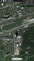
Coordinates reached WRT GPS precision. @55.7285,37.4748
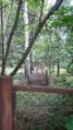
The actual hash seems to be some meters away, behind the fence. @55.7282,37.4737
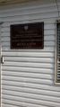
No public access. @55.7282,37.4737


