Difference between revisions of "2013-07-19 26 -80"
imported>Dtobias (Created page with "{{meetup graticule | lat=26 | lon=-80 | date=2013-07-19 | graticule_name=Palm Beach | graticule_link=Palm Beach, Florida}} == About == On the beach in Boca Raton. == Expedi...") |
imported>FippeBot m (Location) |
||
| Line 34: | Line 34: | ||
[[Category:Expeditions with photos]] | [[Category:Expeditions with photos]] | ||
[[Category:Coordinates reached]] | [[Category:Coordinates reached]] | ||
| + | {{location|US|FL|PL}} | ||
Latest revision as of 03:13, 14 August 2019
| Fri 19 Jul 2013 in Palm Beach: 26.3638612, -80.0681179 geohashing.info google osm bing/os kml crox |
Contents
About
On the beach in Boca Raton.
Expedition Reports
Dtobias
This would have been a short walk from my workplace if the Intracoastal Waterway wasn't in the way. As it is, I had to drive a couple of miles to go across on the nearest bridge, then pay $2 to park near the beach. The map in this site and my iPhone's Google Maps app didn't quite see eye-to-eye about the exact location; this site shows it right on the ocean shore next to one of the lifeguard stations, while the app pinpointed it on the nearby boardwalk. I covered all bases by reaching both spots, getting my sandals a bit wet and sandy.
Photos
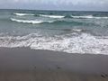
The ocean shore at the spot this site shows for the hashpoint.
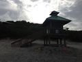
The lifeguard station by the spot; no guard was present.
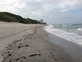
Another view of the beach at the spot.
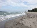
Still another beach view.
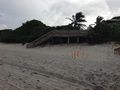
Yet another beach view, with the boardwalk visible.
The spot on the boardwalk where my iPhone thought the hashpoint was.
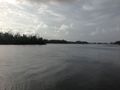
The Intracoastal near my parking spot. You can actually see the building I work in across the water.
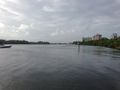
Another Intracoastal view.
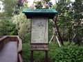
Gumbo Limbo Nature Center boardwalk trail begins near where I parked. It closed at 4 PM.
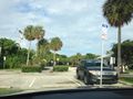
View from my parking space towards the beach.
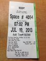
Parking machine ticket.


