Difference between revisions of "2013-07-21 47 8"
imported>Chris 47 8 (expedition added) |
imported>Chris 47 8 m (ribbons added) |
||
| Line 41: | Line 41: | ||
== Achievements == | == Achievements == | ||
| − | {{#vardefine:ribbonwidth| | + | {{#vardefine:ribbonwidth|500px}} |
| − | |||
| + | {{bicycle geohash | ||
| + | | latitude = 47 | ||
| + | | longitude = 8 | ||
| + | | date = 2013-07-21 | ||
| + | | name = [[User:Chris_47_8|Chris_47_8]] | ||
| + | | distance = 26km | ||
| + | }} | ||
| + | {{Land geohash|latitude=47|longitude=8|date=2013-07-21|name=[[User:Chris_47_8|Chris_47_8]]}} | ||
[[Category:Expeditions]] | [[Category:Expeditions]] | ||
[[Category:Expeditions with photos]] | [[Category:Expeditions with photos]] | ||
[[Category:Coordinates reached]] | [[Category:Coordinates reached]] | ||
Revision as of 19:59, 21 July 2013

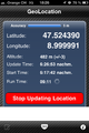
| Sun 21 Jul 2013 in 47,8: 47.5081489, 8.9933500 geohashing.info google osm bing/os kml crox |
Location
Near the village of Lommis.
Participants
Plans
Go there by bike.
Expedition
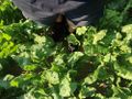
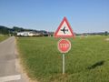
On such a beautiful sunny sunday, i decided to go for today's hash by bike. It was about 25km from home, which is no distance. I biked there and immediately found the place. No big deal. :) The hash was in a vegetable field, but i have no idea what sort of vegatable it was. Has anyone an idea?
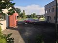
While standing at the hashplace, i saw a small plane landing not far away. I knew that there was a small airstrip (with restaurant) not far away, so I decided to go there and have an ice cream. The airfield was just on the other side of the town. While is was sitting there and enjoying my ice cream, i checked Google Maps and realized that the graticule border to 47,9 goes right thru the airfield.
Tracklog
n/a
Photos
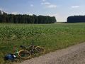
The hash is in this field.
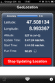
Coordinates reached.
Exactly here.
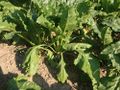
What sort of vegetable is that?
A small airfield.
Graticule border.
Parked plane, almost exactly on the graticule border.
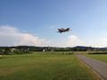
Landing plane.


Achievements
Chris_47_8 earned the Bicycle geohash achievement
|
Chris_47_8 earned the Land geohash achievement
|