Difference between revisions of "2013-08-06 51 9"
imported>Jiml m (Adjust result codes) |
imported>GeorgDerReisende |
||
| Line 20: | Line 20: | ||
== Expedition == | == Expedition == | ||
| − | + | ||
| + | I started at home at 7:00, took a tram to Vellmar, from there I have taken the bus to Calden airport (Kassel International Airport, one or two departures weekly). From there I hitchhiked to Niederlistingen, I had to wait for 30 minutes. From Niederlistingen I walked to Oberlistingen, looking for the hash. There it was. I have taken some photos and then I went home. I couldn't use the national road, because there had been roadworks, so I decided to take the motorway at Breuna. On the way back to the village I have seen some sheep. For Breuna I had to wait two minutes and at the junction to the motorway for about 20 minutes, then I got a truck to the service station Kassel, from there I walked to IKEA, where I have taken the bus to the city, where I arrived at 11:30. | ||
== Tracklog == | == Tracklog == | ||
| Line 30: | Line 31: | ||
--> | --> | ||
<gallery perrow="5"> | <gallery perrow="5"> | ||
| + | Image:2013-08-06 51 9 GeorgDerReisende 7603.jpg | Calden airport | ||
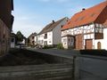
| + | Image:2013-08-06 51 9 GeorgDerReisende 7615.jpg | houses in Oberlistingen | ||
| + | Image:2013-08-06 51 9 GeorgDerReisende 7616.jpg | houses in Oberlistingen | ||
| + | Image:2013-08-06 51 9 GeorgDerReisende 7617.jpg | the fire brigade and the church of Oberlistingen | ||
| + | Image:2013-08-06 51 9 GeorgDerReisende 7624.jpg | houses in Oberlistingen | ||
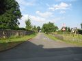
| + | Image:2013-08-06 51 9 GeorgDerReisende 7626.jpg | the street to the hash | ||
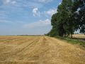
| + | Image:2013-08-06 51 9 GeorgDerReisende 7631.jpg | reached the hash | ||
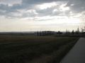
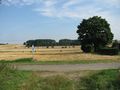
| + | Image:2013-08-06 51 9 GeorgDerReisende 7632.jpg | view to the north | ||
| + | Image:2013-08-06 51 9 GeorgDerReisende 7633.jpg | view to the west | ||
| + | Image:2013-08-06 51 9 GeorgDerReisende 7634.jpg | view to the south | ||
| + | Image:2013-08-06 51 9 GeorgDerReisende 7635.jpg | view to Oberlistingen | ||
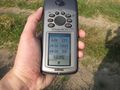
| + | Image:2013-08-06 51 9 GeorgDerReisende 7640.jpg | proof | ||
| + | Image:2013-08-06 51 9 GeorgDerReisende 7647.jpg | the grin | ||
| + | Image:2013-08-06 51 9 GeorgDerReisende 7654.jpg | sheep! | ||
</gallery> | </gallery> | ||
== Achievements == | == Achievements == | ||
{{#vardefine:ribbonwidth|800px}} | {{#vardefine:ribbonwidth|800px}} | ||
| − | |||
| + | {{land geohash | latitude = 51 | longitude = 9 | date = 2013-08-06 | name = GeorgDerReisende }} | ||
| − | + | {{Thumbs Up | latitude = 51 | longitude = 9 | date = 2013-08-06 | name = GeorgDerReisende }} | |
| − | |||
| − | |||
| − | + | [[Category:Expeditions]] | |
| − | |||
| − | [[Category: | ||
| + | [[Category:Expeditions with photos]] | ||
| − | |||
| − | |||
| − | |||
| − | |||
| − | |||
| − | |||
| − | |||
| − | |||
| − | |||
[[Category:Coordinates reached]] | [[Category:Coordinates reached]] | ||
| − | |||
| − | |||
| − | |||
| − | |||
| − | |||
| − | |||
| − | |||
| − | |||
| − | |||
| − | |||
| − | |||
| − | |||
| − | |||
| − | |||
| − | |||
| − | |||
| − | |||
| − | |||
Revision as of 11:08, 6 August 2013
| Tue 6 Aug 2013 in 51,9: 51.4455785, 9.2272871 geohashing.info google osm bing/os kml crox |
Location
The hash lies in the Hohenloher Weg in Oberlistingen near Warburg.
Participants
Plans
I want to go to Calden by public transport and from there I want to hitchhike to Oberlistingen, go to the hash, taking some photos and return home, also by hitchhiking. Visits to other hashes are not planned, because thunderstorms are announced (bad for hitchhiking).
Expedition
I started at home at 7:00, took a tram to Vellmar, from there I have taken the bus to Calden airport (Kassel International Airport, one or two departures weekly). From there I hitchhiked to Niederlistingen, I had to wait for 30 minutes. From Niederlistingen I walked to Oberlistingen, looking for the hash. There it was. I have taken some photos and then I went home. I couldn't use the national road, because there had been roadworks, so I decided to take the motorway at Breuna. On the way back to the village I have seen some sheep. For Breuna I had to wait two minutes and at the junction to the motorway for about 20 minutes, then I got a truck to the service station Kassel, from there I walked to IKEA, where I have taken the bus to the city, where I arrived at 11:30.
Tracklog
Photos
Calden airport
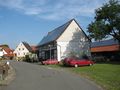
houses in Oberlistingen
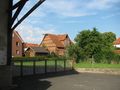
houses in Oberlistingen
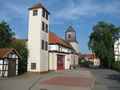
the fire brigade and the church of Oberlistingen
houses in Oberlistingen
the street to the hash
reached the hash
view to the north
view to the west
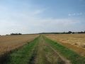
view to the south
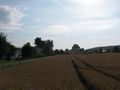
view to Oberlistingen
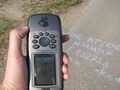
proof

the grin
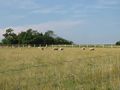
sheep!


Achievements
GeorgDerReisende earned the Land geohash achievement
|
GeorgDerReisende earned the Thumbs Up Geohash Achievement
|