Difference between revisions of "2013-08-10 39 -77"
From Geohashing
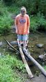
imported>OfficeLinebacker ([live picture] Allison cross the creek on the hike to the damn [http://www.openstreetmap.org/?lat=39.01277270&lon=-77.53244040&zoom=16&layers=B000FTF @39.0128,-77.5324]) |
imported>Calamus m (Categorizing) |
||
| Line 67: | Line 67: | ||
| − | |||
| − | |||
| − | |||
| − | |||
| − | |||
| − | |||
| − | |||
| − | |||
| − | |||
| − | |||
[[Category:Expeditions]] | [[Category:Expeditions]] | ||
| − | |||
[[Category:Expeditions with photos]] | [[Category:Expeditions with photos]] | ||
| − | |||
| − | |||
| − | |||
| − | |||
| − | |||
[[Category:Coordinates reached]] | [[Category:Coordinates reached]] | ||
| − | |||
| − | |||
| − | |||
| − | |||
| − | |||
| − | |||
| − | |||
| − | |||
| − | |||
| − | |||
| − | |||
| − | |||
| − | |||
| − | |||
| − | |||
| − | |||
| − | |||
| − | |||
Revision as of 08:28, 14 September 2013
| Sat 10 Aug 2013 in 39,-77: 39.0075376, -77.5622691 geohashing.info google osm bing/os kml crox |
Location
Participants
Plans
Expedition
- Gonna give this one a try. -- OfficeLinebacker (talk) @39.0930,-77.1553 17:00, 10 August 2013 (EDT)
Tracklog
Photos
Into the forest @39.0079,-77.5607

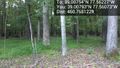
Here! @39.0076,-77.5623
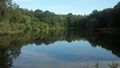
Pond near the hash @39.0070,-77.5631
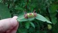
Wacky caterpillar that stung me @39.0068,-77.5632
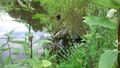
Bad ass spider and its victims @39.0068,-77.5632
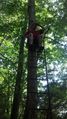
On a ladder stand on lookout duty @39.0075,-77.5619
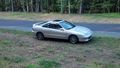
The obligatory picture of the car on the way back. (Yes, I got a new car.) @39.0082,-77.5602
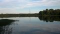
Beaver dam reservoir @39.0145,-77.5421
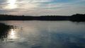
From the other side of the resevoir @39.0108,-77.5341
Allison cross the creek on the hike to the damn @39.0128,-77.5324


