Difference between revisions of "2013-08-16 41 -91"
From Geohashing
imported>Lorelei (→Photos) |
imported>Jiml m (Make assumption about not reaching due to soy density) |
||
| Line 15: | Line 15: | ||
}} | }} | ||
| − | + | ||
__NOTOC__ | __NOTOC__ | ||
== Location == | == Location == | ||
| Line 21: | Line 21: | ||
== Participants == | == Participants == | ||
| − | + | ||
| − | |||
*[[User:Lorelei|Lorelei Coffin]] | *[[User:Lorelei|Lorelei Coffin]] | ||
*Jon | *Jon | ||
| Line 30: | Line 29: | ||
== Expedition == | == Expedition == | ||
| − | + | ||
Started at my house in Coralville. Drove car. Took HWY 6 to HWY 965; took HWY 965 to 76th Ave SW Cedar Rapids. Parked at a factory. Walked through factory parking lot. Walked through Pearson parking lot. Arrived at soy field. Field surrounded by barbed wire fence. Walked along barbed wire fence. Walking through weeds. Found vertical gap in fence. Crossed fence. Walked through weeds between fence and soy around soy. Soy is thick; cross 5 ft into soy and decide to turn back. | Started at my house in Coralville. Drove car. Took HWY 6 to HWY 965; took HWY 965 to 76th Ave SW Cedar Rapids. Parked at a factory. Walked through factory parking lot. Walked through Pearson parking lot. Arrived at soy field. Field surrounded by barbed wire fence. Walked along barbed wire fence. Walking through weeds. Found vertical gap in fence. Crossed fence. Walked through weeds between fence and soy around soy. Soy is thick; cross 5 ft into soy and decide to turn back. | ||
| − | |||
| − | |||
== Photos == | == Photos == | ||
| − | + | ||
| − | |||
| − | |||
<gallery perrow="5"> | <gallery perrow="5"> | ||
</gallery> | </gallery> | ||
<gallery perrow="4"> | <gallery perrow="4"> | ||
| − | Image:2013_08_16_41_-91_lantern.jpg| | + | Image:2013_08_16_41_-91_lantern.jpg|Weed |
| − | Image:2013_08_16_41_-91_fence.jpg| | + | Image:2013_08_16_41_-91_fence.jpg|Fence |
| − | Image:2013 08_16_41_-91_corn.jpg | | + | Image:2013 08_16_41_-91_corn.jpg |Dead corn from past |
</gallery> | </gallery> | ||
| Line 53: | Line 48: | ||
| − | |||
| − | |||
| − | |||
| − | + | [[Category:Expeditions]] | |
| − | |||
| − | [[Category: | ||
| − | |||
| − | |||
| − | |||
| − | |||
[[Category:Expeditions with photos]] | [[Category:Expeditions with photos]] | ||
| − | + | [[Category:Coordinates not reached]] | |
| − | |||
| − | |||
| − | |||
| − | |||
| − | [[Category:Coordinates reached]] | ||
| − | |||
| − | |||
| − | |||
| − | |||
[[Category:Not reached - Mother Nature]] | [[Category:Not reached - Mother Nature]] | ||
| − | |||
| − | |||
| − | |||
| − | |||
| − | |||
| − | |||
| − | |||
| − | |||
| − | |||
| − | |||
| − | |||
Revision as of 06:20, 17 August 2013
| Fri 16 Aug 2013 in 41,-91: 41.9088250, -91.6835751 geohashing.info google osm bing/os kml crox |
Location
Soy field at Highway 965 and 76th Ave SW Cedar Rapids.
Participants
- Lorelei Coffin
- Jon
Plans
Expedition
Started at my house in Coralville. Drove car. Took HWY 6 to HWY 965; took HWY 965 to 76th Ave SW Cedar Rapids. Parked at a factory. Walked through factory parking lot. Walked through Pearson parking lot. Arrived at soy field. Field surrounded by barbed wire fence. Walked along barbed wire fence. Walking through weeds. Found vertical gap in fence. Crossed fence. Walked through weeds between fence and soy around soy. Soy is thick; cross 5 ft into soy and decide to turn back.
Photos
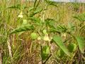
Weed
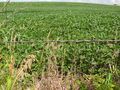
Fence
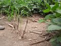
Dead corn from past


