Difference between revisions of "2013-09-07 43 -116"
imported>Eldin ([live] Success!) |
imported>Eldin (add photos and fill in expedition details.) |
||
| Line 1: | Line 1: | ||
| − | |||
| − | |||
| − | |||
| − | |||
| − | |||
| − | |||
| − | |||
| − | |||
| − | |||
| − | |||
{{meetup graticule | {{meetup graticule | ||
| lat=43 | | lat=43 | ||
| Line 15: | Line 5: | ||
}} | }} | ||
| − | |||
__NOTOC__ | __NOTOC__ | ||
| Line 28: | Line 17: | ||
== Expedition == | == Expedition == | ||
| − | + | I arrived at the turn off from the highway just a little after 4pm, to find that the dirt road heading towards the hash was marked with a 'Road Closed' sign. This was a bit over 2 miles from the actual hash. Disappointed, but undaunted, I parked my car and set off walking towards the hash. About a quarter of a mile down the road, I started to see signs of recent flooding. A bit further along, I found a spot where about 30% of the width of the road was washed out. I followed the road to a point about 500 yards from the hash, then turned and walked across the desert for the remaining difference, avoiding patches of mud which remained from the recent flood. But once I got a couple hundred feet from the road, all signs of the flood vanished. Getting to the hash from here wasn't too difficult, though I took a somewhat indirect route to avoid some rather steep slopes. Once at the hash, I took pictures, and turned around to head back to my car. As I was walking back to my car, I noticed a tractor on the road behind me, heading very slowly in my direction. It caught up to me maybe a quarter of a mile before I reached my car. The driver got out and asked if I would like a lift, which I accepted. The tractor was easier than walking, though probably only 50% faster. It was being driven by a local farmer who was attempting to re-surface the damaged road somewhat. I asked him about the flood damage, and he said that just yesterday, they'd had rain in a narrow corridor through the area which caused flash floods. The area where any rain at all fell was less than a mile wide, but had roughly followed the course of the road. He informed me that the area gets flash floods like that maybe once every 40-50 years. after about 10 minutes of riding with him, he dropped me off at my car. I thanked him for the ride, and headed home. | |
| − | |||
| Line 36: | Line 24: | ||
*Success! -- [[User:Eldin|Eldin]] ([[User talk:Eldin|talk]]) [http://www.openstreetmap.org/?lat=43.24319313&lon=-116.52702922&zoom=16&layers=B000FTF @43.2432,-116.5270] 17:39, 7 September 2013 (MDT) | *Success! -- [[User:Eldin|Eldin]] ([[User talk:Eldin|talk]]) [http://www.openstreetmap.org/?lat=43.24319313&lon=-116.52702922&zoom=16&layers=B000FTF @43.2432,-116.5270] 17:39, 7 September 2013 (MDT) | ||
| + | |||
== Photos == | == Photos == | ||
| − | |||
| − | |||
| − | |||
<gallery perrow="5"> | <gallery perrow="5"> | ||
| + | File:2013-09-07 43 -116 proof.jpg | The proof that the hash was reached. | ||
| + | File:2013-09-07 43 -116 grin.jpg | Me, grinning at the hashpoint. | ||
| + | File:2013-09-07 43 -116 sign.jpg | A sign that this hash won't be quite as easy as originally anticipated. | ||
| + | File:2013-09-07 43 -116 hashpoint.jpg | The actual spot. | ||
| + | File:2013-09-07 43 -116 road1.jpg | Washed out area on the side of the road. | ||
| + | File:2013-09-07 43 -116 road2.jpg | An area where about a third of the road had washed out. | ||
| + | File:2013-09-07 43 -116 view1.jpg | The view looking north from the hash. | ||
| + | File:2013-09-07 43 -116 view2.jpg | The view looking east. | ||
| + | File:2013-09-07 43 -116 view3.jpg | The view looking south (the direction I walked from) | ||
| + | |||
</gallery> | </gallery> | ||
== Achievements == | == Achievements == | ||
{{#vardefine:ribbonwidth|800px}} | {{#vardefine:ribbonwidth|800px}} | ||
| − | + | {{Land geohash|latitude=43|longitude=-116|date=2013-09-07|name=[[User:Eldin|Eldin]]}} | |
| − | |||
| − | |||
| − | |||
| − | [[ | ||
| − | |||
| − | |||
| − | |||
| − | |||
| − | |||
| − | |||
[[Category:Expeditions]] | [[Category:Expeditions]] | ||
| − | |||
[[Category:Expeditions with photos]] | [[Category:Expeditions with photos]] | ||
| − | |||
| − | |||
| − | |||
| − | |||
| − | |||
[[Category:Coordinates reached]] | [[Category:Coordinates reached]] | ||
| − | |||
| − | |||
| − | |||
| − | |||
| − | |||
| − | |||
| − | |||
| − | |||
| − | |||
| − | |||
| − | |||
| − | |||
| − | |||
| − | |||
| − | |||
| − | |||
| − | |||
| − | |||
Revision as of 06:19, 8 September 2013
| Sat 7 Sep 2013 in 43,-116: 43.2431893, -116.5270279 geohashing.info google osm bing/os kml crox |
Location
In the desert NE of Murphy
Participants
Plans
I'm going to try to get there this afternoon, hopefully sometime between 3 and 4.
Expedition
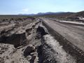
I arrived at the turn off from the highway just a little after 4pm, to find that the dirt road heading towards the hash was marked with a 'Road Closed' sign. This was a bit over 2 miles from the actual hash. Disappointed, but undaunted, I parked my car and set off walking towards the hash. About a quarter of a mile down the road, I started to see signs of recent flooding. A bit further along, I found a spot where about 30% of the width of the road was washed out. I followed the road to a point about 500 yards from the hash, then turned and walked across the desert for the remaining difference, avoiding patches of mud which remained from the recent flood. But once I got a couple hundred feet from the road, all signs of the flood vanished. Getting to the hash from here wasn't too difficult, though I took a somewhat indirect route to avoid some rather steep slopes. Once at the hash, I took pictures, and turned around to head back to my car. As I was walking back to my car, I noticed a tractor on the road behind me, heading very slowly in my direction. It caught up to me maybe a quarter of a mile before I reached my car. The driver got out and asked if I would like a lift, which I accepted. The tractor was easier than walking, though probably only 50% faster. It was being driven by a local farmer who was attempting to re-surface the damaged road somewhat. I asked him about the flood damage, and he said that just yesterday, they'd had rain in a narrow corridor through the area which caused flash floods. The area where any rain at all fell was less than a mile wide, but had roughly followed the course of the road. He informed me that the area gets flash floods like that maybe once every 40-50 years. after about 10 minutes of riding with him, he dropped me off at my car. I thanked him for the ride, and headed home.
- The road nearest the hash is closed, apparently due to recent flooding. Posting this while proceeding towards the hash on foot. -- Eldin (talk) @43.2284,-116.5501 16:36, 7 September 2013 (MDT)
- Success! -- Eldin (talk) @43.2432,-116.5270 17:39, 7 September 2013 (MDT)
Photos
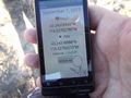
The proof that the hash was reached.

Me, grinning at the hashpoint.

A sign that this hash won't be quite as easy as originally anticipated.
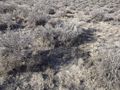
The actual spot.
Washed out area on the side of the road.
An area where about a third of the road had washed out.
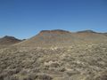
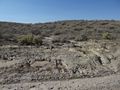
The view looking north from the hash.
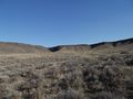
The view looking east.
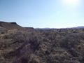
The view looking south (the direction I walked from)


Achievements
Eldin earned the Land geohash achievement
|