Difference between revisions of "2013-09-23 41 -112"
From Geohashing
imported>Eldin (initial report) |
imported>Jiml m (Adjust result codes) |
||
| Line 36: | Line 36: | ||
<!-- Add any achievement ribbons you earned below, or remove this section --> | <!-- Add any achievement ribbons you earned below, or remove this section --> | ||
| + | * Land Geohash | ||
| − | |||
| − | |||
| − | |||
| − | + | [[Category:Expeditions]] | |
| − | |||
| − | [[Category: | ||
| − | |||
| − | |||
| − | |||
| − | |||
[[Category:Expeditions with photos]] | [[Category:Expeditions with photos]] | ||
| − | + | ||
| − | |||
| − | |||
| − | |||
| − | |||
[[Category:Coordinates reached]] | [[Category:Coordinates reached]] | ||
| − | |||
| − | |||
| − | |||
| − | |||
| − | |||
| − | |||
| − | |||
| − | |||
| − | |||
| − | |||
| − | |||
| − | |||
| − | |||
| − | |||
| − | |||
| − | |||
| − | |||
| − | |||
Revision as of 12:57, 24 September 2013
| Mon 23 Sep 2013 in 41,-112: 41.3960634, -112.0279539 geohashing.info google osm bing/os kml crox |
Location
In the hills SW of Willard, UT
Participants
Plans
This was very nearly on my way home from Ogden, so I had to stop and try for it.
Expedition
Had paved road to within 350ft of the hash. Took a detour on my way out of town, drove to the vicinity of the hash, parked, and walked the last few hundred feet. Easy hash, nice spot, first try in this graticule. All in all a nice expedition.
- At the coordinates. Pics to follow. -- Eldin (talk) @41.3961,-112.0279 16:13, 23 September 2013 (MDT)
Photos
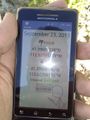
Proof that the coordinates were reached.

Grinning geohasher.
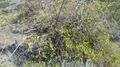
The small tree that was growing at the hashpoint.
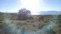
View to the west.
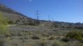
And to the South.
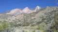
And the East.


Achievements
- Land Geohash