Difference between revisions of "2013-10-29 43 -116"
From Geohashing
imported>Eldin ([live] At the hash! Pics to follow.) |
imported>Eldin (add photos and additional details.) |
||
| Line 1: | Line 1: | ||
| − | |||
| − | |||
| − | |||
| − | |||
| − | |||
| − | |||
| − | |||
| − | |||
| − | |||
| − | |||
{{meetup graticule | {{meetup graticule | ||
| lat=43 | | lat=43 | ||
| Line 15: | Line 5: | ||
}} | }} | ||
| − | |||
__NOTOC__ | __NOTOC__ | ||
== Location == | == Location == | ||
| − | + | In the desert just off I-84, north of the sand hollow exit. | |
== Participants == | == Participants == | ||
| − | + | * [[User:Eldin|Eldin]] | |
| − | |||
| − | |||
| − | |||
| − | |||
== Expedition == | == Expedition == | ||
| − | |||
| − | |||
*At the hash! Pics to follow. -- [[User:Eldin|Eldin]] ([[User talk:Eldin|talk]]) [http://www.openstreetmap.org/?lat=43.82527147&lon=-116.76612583&zoom=16&layers=B000FTF @43.8253,-116.7661] 20:23, 29 October 2013 (MDT) | *At the hash! Pics to follow. -- [[User:Eldin|Eldin]] ([[User talk:Eldin|talk]]) [http://www.openstreetmap.org/?lat=43.82527147&lon=-116.76612583&zoom=16&layers=B000FTF @43.8253,-116.7661] 20:23, 29 October 2013 (MDT) | ||
| − | |||
| − | |||
== Photos == | == Photos == | ||
| − | |||
| − | |||
| − | |||
<gallery perrow="5"> | <gallery perrow="5"> | ||
| + | File:2013-10-29 43 -116 proof.jpg | Proof that I was at the spot. | ||
| + | File:2013-10-29 43 -116 grin.jpg | Something like a grin. | ||
| + | File:2013-10-29 43 -116 burrow.jpg | It looks like a badger got a couch potato hash today. | ||
</gallery> | </gallery> | ||
== Achievements == | == Achievements == | ||
{{#vardefine:ribbonwidth|800px}} | {{#vardefine:ribbonwidth|800px}} | ||
| − | |||
| − | |||
| − | |||
| − | |||
| − | |||
| − | |||
| − | |||
| − | |||
| − | |||
| − | |||
| − | |||
| − | |||
[[Category:Expeditions]] | [[Category:Expeditions]] | ||
| − | |||
[[Category:Expeditions with photos]] | [[Category:Expeditions with photos]] | ||
| − | |||
| − | |||
| − | |||
| − | |||
| − | |||
[[Category:Coordinates reached]] | [[Category:Coordinates reached]] | ||
| − | |||
| − | |||
| − | |||
| − | |||
| − | |||
| − | |||
| − | |||
| − | |||
| − | |||
| − | |||
| − | |||
| − | |||
| − | |||
| − | |||
| − | |||
| − | |||
| − | |||
| − | |||
Revision as of 04:41, 30 October 2013
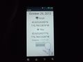
| Tue 29 Oct 2013 in 43,-116: 43.8252639, -116.7661287 geohashing.info google osm bing/os kml crox |
Location
In the desert just off I-84, north of the sand hollow exit.
Participants
Expedition
- At the hash! Pics to follow. -- Eldin (talk) @43.8253,-116.7661 20:23, 29 October 2013 (MDT)
Photos
Proof that I was at the spot.

Something like a grin.
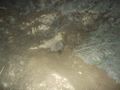
It looks like a badger got a couch potato hash today.


