Difference between revisions of "2013-11-18 19 -154"
From Geohashing
imported>Simonradford |
imported>FippeBot m (Location) |
||
| Line 60: | Line 60: | ||
[[Category:Expeditions with photos]] | [[Category:Expeditions with photos]] | ||
[[Category:Coordinates reached]] | [[Category:Coordinates reached]] | ||
| + | {{location|US|HI|HA}} | ||
Revision as of 04:41, 14 August 2019
| Mon 18 Nov 2013 in 19,-154: 19.5073886, -154.8233696 geohashing.info google osm bing/os kml crox |
Location
In a lava flow near the eastern tip of the island near Kapoho.
Participants
Plans
No planning, per se. The hash point was on land(!) and close to a road. Hard to pass up.
Expedition
Parked along the road then picked my way over the 'a'a lava flow to the hash point. Found an easier route in the way back. The flow is probably from 1960.
Photos
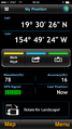
GPS display.
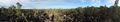
Lava flow and plants.
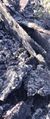
'A'a lava makes for rough walking.

I was there.


