Difference between revisions of "2013-12-16 49 2"
imported>Zertrin (creating expedition page) |
imported>Zertrin (happy happy happy!!!) |
||
| Line 1: | Line 1: | ||
| − | |||
| − | |||
| − | |||
| − | |||
| − | |||
| − | |||
| − | |||
| − | |||
| − | |||
| − | |||
{{meetup graticule | {{meetup graticule | ||
| lat=49 | | lat=49 | ||
| Line 15: | Line 5: | ||
}} | }} | ||
| − | |||
__NOTOC__ | __NOTOC__ | ||
== Location == | == Location == | ||
| − | + | 10 km NNE of CDG airport, near the TGV line, in a field near Beaumarchais. | |
== Participants == | == Participants == | ||
| − | + | * [[User:Vermouthandgin|Vermouthandgin]] | |
| − | + | * [[User:Zertrin|Zertrin]] | |
== Plans == | == Plans == | ||
| − | + | Pick [[User:Vermouthandgin|Vermouthandgin]] at Charles de Gaulle's airport and try to reach the hash while driving back home to the north of France. | |
== Expedition == | == Expedition == | ||
| − | + | [[User:Vermouthandgin|Vermouthandgin]] arrived on early morning (5:40 a.m.) at Charles de Gaulle's airport and [[User:Zertrin|Zertrin]] was coming from the north of France to pick her up. We noticed that today's hash in [[49 2]] was relatively close to the airport and potentially reachable. | |
| + | |||
| + | After leaving the airport and taking the A1 motorway directly by mistake (airport exits are always a bit misleading) we took the first exit. From Saint-Witz we drove as close as possible to the hash and walked the remaining 600 meters. | ||
| + | |||
| + | The hash was 10 meters off the path in a beet field. After taking the usual pictures (or at least trying to take them in the dark) we headed back to the car and drove back home. | ||
== Tracklog == | == Tracklog == | ||
| Line 38: | Line 31: | ||
--> | --> | ||
<gallery perrow="5"> | <gallery perrow="5"> | ||
| + | Image:2013-12-16 49 2 - Zertrin - GPS Coordinates.png | Coordinates reached! | ||
| + | Image:2013-12-16 49 2 - Vermouthandgin and Zertrin at hashpoint.JPG | [[User:Vermouthandgin|Vermouthandgin]] and [[User:Zertrin|Zertrin]] at the hashpoint | ||
| + | Image:2013-12-16 49 2 - Zertrin - The field.JPG | The field where the hashpoint was located | ||
</gallery> | </gallery> | ||
| Line 45: | Line 41: | ||
| − | |||
| − | |||
| − | |||
| − | |||
| − | |||
| − | |||
| − | |||
| − | |||
| − | |||
| − | |||
[[Category:Expeditions]] | [[Category:Expeditions]] | ||
| − | |||
[[Category:Expeditions with photos]] | [[Category:Expeditions with photos]] | ||
| − | |||
| − | |||
| − | |||
| − | |||
[[Category:Coordinates reached]] | [[Category:Coordinates reached]] | ||
| − | |||
| − | |||
| − | |||
| − | |||
| − | |||
| − | |||
| − | |||
| − | |||
| − | |||
| − | |||
| − | |||
| − | |||
| − | |||
| − | |||
| − | |||
| − | |||
| − | |||
| − | |||
Revision as of 12:08, 18 December 2013
| Mon 16 Dec 2013 in 49,2: 49.0892412, 2.6477338 geohashing.info google osm bing/os kml crox |
Location
10 km NNE of CDG airport, near the TGV line, in a field near Beaumarchais.
Participants
Plans
Pick Vermouthandgin at Charles de Gaulle's airport and try to reach the hash while driving back home to the north of France.
Expedition
Vermouthandgin arrived on early morning (5:40 a.m.) at Charles de Gaulle's airport and Zertrin was coming from the north of France to pick her up. We noticed that today's hash in 49 2 was relatively close to the airport and potentially reachable.
After leaving the airport and taking the A1 motorway directly by mistake (airport exits are always a bit misleading) we took the first exit. From Saint-Witz we drove as close as possible to the hash and walked the remaining 600 meters.
The hash was 10 meters off the path in a beet field. After taking the usual pictures (or at least trying to take them in the dark) we headed back to the car and drove back home.
Tracklog
Photos
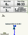
Coordinates reached!

Vermouthandgin and Zertrin at the hashpoint

The field where the hashpoint was located


