Difference between revisions of "2013-12-18 34 -118"
From Geohashing
imported>Bravissimo594 |
imported>Bravissimo594 (→Participants) |
||
| Line 24: | Line 24: | ||
<!-- who attended: If you link to your wiki user name in this section, your expedition will be picked up by the various statistics generated for geohashing. You may use three tildes ~ as a shortcut to automatically insert the user signature of the account you are editing with. | <!-- who attended: If you link to your wiki user name in this section, your expedition will be picked up by the various statistics generated for geohashing. You may use three tildes ~ as a shortcut to automatically insert the user signature of the account you are editing with. | ||
--> | --> | ||
| − | [[User:Bravissimo594|Bravissimo594]] | + | * [[User:Bravissimo594|Bravissimo594]] |
| + | * [[User:Boppy5|Boppy5]] | ||
== Plans == | == Plans == | ||
Revision as of 22:03, 22 December 2013
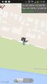
| Wed 18 Dec 2013 in 34,-118: 34.1578549, -118.2998052 geohashing.info google osm bing/os kml crox |
Location
Rancho Avenue, along the north edge of the Bette Davis Picnic Area in Griffith Park.
Participants
Plans
Bravissimo594 and Boppy plan to drive to the location sometime between 2:30pm and 3:30pm.
Expedition
We met in La Canada and drove from there to the location. Not wanting to miss the freeway exit, I left I-5 one stop too early and got to drive past the Los Angeles Zoo, taking surface streets to the hash point. Once there, Boppy got to play with a golden retriever / husky mix puppy. We snapped a few photos of ourselves, pondered whether each passing car might be a fellow geohasher, and then headed back to La Canada. Successful first expedition for us both.
Tracklog
Photos
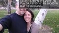
Made it, and got to play with a puppy in the picnic area. @34.1578,-118.3000
Geohash Droid


Achievements