Difference between revisions of "2013-12-29 43 -123"
imported>Michael5000 (→Photos) |
imported>Michael5000 m (→Achievements) |
||
| Line 53: | Line 53: | ||
{{#vardefine:ribbonwidth|800px}} | {{#vardefine:ribbonwidth|800px}} | ||
<!-- Add any achievement ribbons you earned below, or remove this section --> | <!-- Add any achievement ribbons you earned below, or remove this section --> | ||
| + | |||
| + | {{Virgin graticule | ||
| + | |||
| + | | latitude = 43 | ||
| + | | longitude = -123 | ||
| + | | date = 2013-12-29 | ||
| + | | name = [[User:Michael5000|Michael5000]], [[User:Mrs.5000|Mrs.5000]], and Niece #4 | ||
| + | | image = 2013-12-29 43 -123 6.JPG | ||
| + | |||
| + | }} | ||
Revision as of 00:49, 30 December 2013
| Sun 29 Dec 2013 in 43,-123: 43.7846778, -123.1664268 geohashing.info google osm bing/os kml crox |
Location
Off Gowdyville Road in the woods west of Cottage Grove.
Participants
- Michael5000
- Mrs.5000
- Niece #4
Plans
Returning from the South Coast to Portland after the holidays, we noticed a potential hashpoint not too far off of the route, as long as "the route" meant crossing the Coast Range on the road from Reedsport to Drain. So obviously, we turned inland at Reedsport.
Expedition
Gowdyville Road turned to gravel, but took us to within about 200 feet of the hashpoint. We crunched through the underbrush to the "South Fork Siuslaw River," which this far up is nothing but a little creek with a fancy name. Michael waded across, while Mrs. and Niece #4 spent a little more time scouting and found a dry way to cross. A little more crashing through brush, and we were at the hashpoint!
A good time was had by all.
Tracklog
Photos
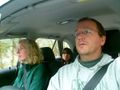
We approach the hashpoint by car.
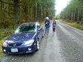
Preparing for the final approach.
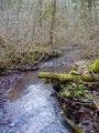
Confronted by the mighty South Fork Siuslaw River.
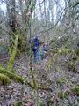
Mrs.5000 and Niece #4 approach the hashpoint.

The expedition party enjoys its triumph.


