Difference between revisions of "2014-02-01 42 -85"
imported>Mcbaneg (Created page with "<!-- If you did not specify these parameters in the template, please substitute appropriate values for IMAGE, LAT, LON, and DATE (YYYY-MM-DD format) {{{image|dummy.jpg}}}|...") |
imported>Mcbaneg |
||
| Line 27: | Line 27: | ||
== Expedition == | == Expedition == | ||
| − | We were going out to Allendale to deliver a bookcase to my office, and I checked for hashpoints before we left. The hashpoint was actually right on campus, on the golf course a few hundred meters from the building where I work. The course is closed for the season, but I was confident we should be able to get access. We took a printed screenshot of the satmap and a compass. I figured we would be able to triangulate using the athletic training building and the campus water tower. | + | We were going out to Allendale to deliver a bookcase to my office, and I checked for hashpoints before we left. The hashpoint was actually right on campus, on the golf course a few hundred meters from the building where I work. The course is closed for the season, but I was confident we should be able to get access. We took a printed screenshot of the satmap and a compass. I figured we would be able to triangulate using the athletic training building and the campus water tower. We were able to walk part of the way on plowed parking lots (scaling the 5-foot snow ridges between rows of cars) and sidewalks until we got west of the women's softball field, but then had to take off through the snow. It was about knee-deep, and we had maybe a hundred meters to go. Halfway along was a cyclone fence that marked the perimeter of the golf course. It's probably about 4 feet high, but the snow had drifted against it so that the part we had to get over was less than 2 feet and it didn't present much of a barrier. Once on the course, the snow was sometimes stiff enough to walk on top of Legolas-style, but sometimes soft. We found that the water tower was not visible because of an intervening hill. However, we could see both the grandstand of the football stadium and the campus belltower, and those served as direction markers so we could find the point. |
| − | |||
| − | |||
| − | and we had maybe a hundred meters to go. Halfway along was a cyclone fence that marked the perimeter of the golf course. It's probably | ||
| − | about 4 feet high, but the snow had drifted against it so that the part we had to get over was less than 2 feet and it didn't present much of a barrier. Once on the course, the snow was sometimes stiff enough to walk on top of Legolas-style, but sometimes soft. We found that the water tower was not visible because of an intervening hill. However, we could see both the grandstand of the football stadium and the campus belltower, and those served as direction markers so we could find the point. | ||
Rebekah stomped a big XKCD into the snow, but our photo has so little contrast that it's not convincing. | Rebekah stomped a big XKCD into the snow, but our photo has so little contrast that it's not convincing. | ||
Revision as of 05:37, 2 February 2014
| Sat 1 Feb 2014 in 42,-85: 42.9662171, -85.8959396 geohashing.info google osm bing/os kml crox |
Location
between the 14th and 15th fairways at Meadows Golf Course on the campus of Grand Valley State University, Allendale, MI, USA
Participants
Expedition
We were going out to Allendale to deliver a bookcase to my office, and I checked for hashpoints before we left. The hashpoint was actually right on campus, on the golf course a few hundred meters from the building where I work. The course is closed for the season, but I was confident we should be able to get access. We took a printed screenshot of the satmap and a compass. I figured we would be able to triangulate using the athletic training building and the campus water tower. We were able to walk part of the way on plowed parking lots (scaling the 5-foot snow ridges between rows of cars) and sidewalks until we got west of the women's softball field, but then had to take off through the snow. It was about knee-deep, and we had maybe a hundred meters to go. Halfway along was a cyclone fence that marked the perimeter of the golf course. It's probably about 4 feet high, but the snow had drifted against it so that the part we had to get over was less than 2 feet and it didn't present much of a barrier. Once on the course, the snow was sometimes stiff enough to walk on top of Legolas-style, but sometimes soft. We found that the water tower was not visible because of an intervening hill. However, we could see both the grandstand of the football stadium and the campus belltower, and those served as direction markers so we could find the point.
Rebekah stomped a big XKCD into the snow, but our photo has so little contrast that it's not convincing.
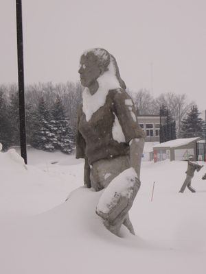
On the way back we passed a statue by the softball field. It's of a young woman with softball gear, but the snow sticking to the statue formed glasses and a shawl that made her look like an old woman.
We didn't have a thermometer but stations at both (42.972, -86.076) and (42.998, -85.810) show between -3 and -4 °C at 3:30 pm when we were there.
Achievements
George and Rebekah earned the Land geohash achievement
|
George and Rebekah earned the No Batteries Geohash Achievement
|
George and Rebekah earned the Frozen Geohash Achievement
|


