Difference between revisions of "2014-03-16 -35 149"
From Geohashing
imported>1PE (Created page with "{{subst:Expedition |lat = -35 |lon = 149 |date = 2014-03-16 }}") |
imported>1PE |
||
| Line 18: | Line 18: | ||
__NOTOC__ | __NOTOC__ | ||
== Location == | == Location == | ||
| − | + | Near the entrance of the Mulligans Flat–Goorooyarroo Woodland, near the Federal Highway. | |
== Participants == | == Participants == | ||
| − | + | * [[User:1PE|1PE]] | |
| − | |||
== Plans == | == Plans == | ||
| − | + | ===[[User:1PE|1PE]]=== | |
| + | Go out of my way while traveling to my community radio station, to do a shift. | ||
== Expedition == | == Expedition == | ||
| − | + | I went along the Federal Highway to the Horse Park Drive exit. The hash is just west of the road interchange. I turned into a road access and discovered that it leads to part of the [http://www.mfgowoodlandexperiment.org.au/ Mulligans Flat–'''Goorooyarroo''' Woodland]. Access was easy, onto the road leading away from the gate (of many locks.) The hash was a short distance uphill. | |
== Tracklog == | == Tracklog == | ||
| Line 38: | Line 38: | ||
--> | --> | ||
<gallery perrow="5"> | <gallery perrow="5"> | ||
| + | Image:2014-03-14_-35_149_a.jpg|Down the hill. | ||
| + | Image:2014-03-14_-35_149_b.jpg|Sign. Say it like it looks. | ||
| + | Image:2014-03-14 -35 149 c.jpg|Locks, to allow access by lots of different organisations. | ||
</gallery> | </gallery> | ||
| Line 45: | Line 48: | ||
| − | + | ||
| − | |||
[[Category:New report]] | [[Category:New report]] | ||
| − | |||
| − | |||
| − | |||
| − | |||
| − | |||
| − | |||
| − | |||
| − | |||
| − | |||
[[Category:Expeditions]] | [[Category:Expeditions]] | ||
| − | |||
[[Category:Expeditions with photos]] | [[Category:Expeditions with photos]] | ||
| − | |||
| − | |||
| − | |||
| − | |||
| − | |||
[[Category:Coordinates reached]] | [[Category:Coordinates reached]] | ||
| − | |||
| − | |||
| − | |||
| − | |||
| − | |||
| − | |||
| − | |||
| − | |||
| − | |||
| − | |||
| − | |||
| − | |||
| − | |||
| − | |||
| − | |||
| − | |||
| − | |||
| − | |||
Revision as of 03:28, 16 March 2014
| Sun 16 Mar 2014 in -35,149: -35.2119265, 149.1802563 geohashing.info google osm bing/os kml crox |
Location
Near the entrance of the Mulligans Flat–Goorooyarroo Woodland, near the Federal Highway.
Participants
Plans
1PE
Go out of my way while traveling to my community radio station, to do a shift.
Expedition
I went along the Federal Highway to the Horse Park Drive exit. The hash is just west of the road interchange. I turned into a road access and discovered that it leads to part of the Mulligans Flat–Goorooyarroo Woodland. Access was easy, onto the road leading away from the gate (of many locks.) The hash was a short distance uphill.
Tracklog
Photos

Down the hill.
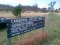
Sign. Say it like it looks.
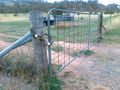
Locks, to allow access by lots of different organisations.


