Difference between revisions of "2014-04-27 34 -118"
From Geohashing
imported>Bravissimo594 m ([live picture] Street chalk at the spot. [http://www.openstreetmap.org/?lat=34.07040000&lon=-118.27300000&zoom=16&layers=B000FTF @34.0704,-118.2730]) |
imported>Bravissimo594 m ([live picture] Marked with information. [http://www.openstreetmap.org/?lat=34.07040000&lon=-118.27300000&zoom=16&layers=B000FTF @34.0704,-118.2730]) |
||
| Line 48: | Line 48: | ||
Image:2014-04-27_34_-118_Bravissimo594_1398654113703.jpg | Street chalk at the spot. [http://www.openstreetmap.org/?lat=34.07040000&lon=-118.27300000&zoom=16&layers=B000FTF @34.0704,-118.2730] | Image:2014-04-27_34_-118_Bravissimo594_1398654113703.jpg | Street chalk at the spot. [http://www.openstreetmap.org/?lat=34.07040000&lon=-118.27300000&zoom=16&layers=B000FTF @34.0704,-118.2730] | ||
| + | |||
| + | Image:2014-04-27_34_-118_Bravissimo594_1398654318736.jpg | Marked with information. [http://www.openstreetmap.org/?lat=34.07040000&lon=-118.27300000&zoom=16&layers=B000FTF @34.0704,-118.2730] | ||
</gallery> | </gallery> | ||
Revision as of 03:07, 28 April 2014
| Sun 27 Apr 2014 in 34,-118: 34.0703144, -118.2727035 geohashing.info google osm bing/os kml crox |
Location
- In front of a residence in Historic Filipinotown. Los Angeles graticule.
Participants
Plans and Tools
- Aiming for 8:00pm tonight. Bravissimo594 (talk) 22:05, 27 April 2014 (EDT)
PDF poster for this location. (More information at User:Crox/Poster.)
Expedition
Tracklog
Photos
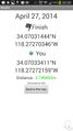
Success! Geohash Droid details. @34.0704,-118.2727
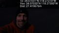
Under nearby street light. @34.0703,-118.2730
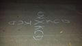
Street chalk at the spot. @34.0704,-118.2730
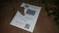
Marked with information. @34.0704,-118.2730


Achievements