Difference between revisions of "2014-05-04 51 9"
From Geohashing
imported>GeorgDerReisende (new expedition) |
imported>GeorgDerReisende (expedition report added) |
||
| Line 1: | Line 1: | ||
| − | |||
| − | |||
| − | |||
| − | |||
| − | |||
| − | |||
| − | |||
| − | |||
| − | |||
| − | |||
{{meetup graticule | {{meetup graticule | ||
| lat=51 | | lat=51 | ||
| Line 18: | Line 8: | ||
__NOTOC__ | __NOTOC__ | ||
== Location == | == Location == | ||
| − | + | ||
| + | The hash lies in the Rieswartenweg in Göttingen. | ||
== Participants == | == Participants == | ||
| − | + | ||
| − | + | [[User:GeorgDerReisende|GeorgDerReisende]] | |
== Plans == | == Plans == | ||
| − | + | ||
| + | I wanted to hitchhike to Göttingen and go to the hash. | ||
== Expedition == | == Expedition == | ||
| − | + | ||
| + | I left home at 11:00 and started to hitchhike at 12:00. I got a lift after five minutes, at the arriving in Göttingen I got the bus to Nikolausberg immediately. There I walked from the terminus of the bus to the hash. I didn't need a dance, the hash lied three meters behind the fence. I took some photos and went away. | ||
== Tracklog == | == Tracklog == | ||
| Line 34: | Line 27: | ||
== Photos == | == Photos == | ||
| − | |||
| − | |||
| − | |||
<gallery perrow="5"> | <gallery perrow="5"> | ||
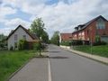
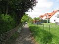
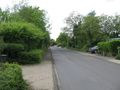
| + | Image:2014-05-04 51 9 GeorgDerReisende 9973.jpg | the Riedwiesenstraße | ||
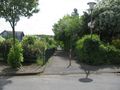
| + | Image:2014-05-04 51 9 GeorgDerReisende 9974.jpg | coming nearer to the hash | ||
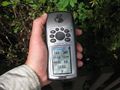
| + | Image:2014-05-04 51 9 GeorgDerReisende 9979.jpg | proof | ||
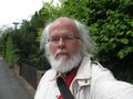
| + | Image:2014-05-04 51 9 GeorgDerReisende 9980.jpg | grin | ||
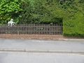
| + | Image:2014-05-04 51 9 GeorgDerReisende 9981.jpg | the mark | ||
| + | Image:2014-05-04 51 9 GeorgDerReisende 9982.jpg | the house | ||
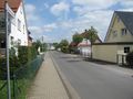
| + | Image:2014-05-04 51 9 GeorgDerReisende 9975.jpg | the way Eschenbreite to the north | ||
| + | Image:2014-05-04 51 9 GeorgDerReisende 9976.jpg | the way Eschenbreite to the south | ||
| + | Image:2014-05-04 51 9 GeorgDerReisende 9977.jpg | view to the east | ||
| + | Image:2014-05-04 51 9 GeorgDerReisende 9984.jpg | view to the west | ||
</gallery> | </gallery> | ||
| Line 44: | Line 44: | ||
<!-- Add any achievement ribbons you earned below, or remove this section --> | <!-- Add any achievement ribbons you earned below, or remove this section --> | ||
| + | {{Thumbs Up | latitude = 51 | longitude = 9 | date = 2014-05-04 | name = GeorgDerReisende }} | ||
| − | + | [[Category:Expeditions]] | |
| − | |||
| − | [[Category: | ||
| − | + | [[Category:Expeditions with photos]] | |
| − | |||
| − | |||
| − | |||
| − | [[Category: | ||
| − | |||
| − | |||
| − | |||
| − | |||
| − | |||
| − | |||
| − | |||
| − | |||
| − | |||
| − | |||
[[Category:Coordinates reached]] | [[Category:Coordinates reached]] | ||
| − | |||
| − | |||
| − | |||
| − | |||
| − | |||
| − | |||
| − | |||
| − | |||
| − | |||
| − | |||
| − | |||
| − | |||
| − | |||
| − | |||
| − | |||
| − | |||
| − | |||
| − | |||
Revision as of 18:29, 4 May 2014
| Sun 4 May 2014 in 51,9: 51.5653046, 9.9848886 geohashing.info google osm bing/os kml crox |
Location
The hash lies in the Rieswartenweg in Göttingen.
Participants
Plans
I wanted to hitchhike to Göttingen and go to the hash.
Expedition
I left home at 11:00 and started to hitchhike at 12:00. I got a lift after five minutes, at the arriving in Göttingen I got the bus to Nikolausberg immediately. There I walked from the terminus of the bus to the hash. I didn't need a dance, the hash lied three meters behind the fence. I took some photos and went away.
Tracklog
Photos
the Riedwiesenstraße

coming nearer to the hash
proof
grin
the mark
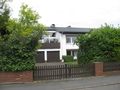
the house
the way Eschenbreite to the north
the way Eschenbreite to the south
view to the east
view to the west


Achievements
GeorgDerReisende earned the Thumbs Up Geohash Achievement
|