Difference between revisions of "2014-05-12 49 8"
From Geohashing
imported>Q-Owl (→Expedition) |
imported>Q-Owl |
||
| Line 27: | Line 27: | ||
== Expedition == | == Expedition == | ||
| + | |||
| + | It was a little detour on my way home after ending with work a little bit earlier. | ||
| + | I drove to Hochstädten, parked the car and had to look for, where the path into the wood might start. Aftr crossing a farmyard I saw th path and went up into the wood until I reached the blind end of the path after 5 or ten minutes. | ||
Success. :-) | Success. :-) | ||
| Line 33: | Line 36: | ||
... | ... | ||
| − | + | ||
<gallery> | <gallery> | ||
| − | Image: | + | Image:Image2014-05-12-010.jpg | HP in the wood above the fire brigade |
| − | Image: | + | Image:Image2014-05-12-008.jpg | The way from a farm yard up into the wood |
</gallery> | </gallery> | ||
| − | + | <!-- | |
<gallery> | <gallery> | ||
Image:20140329_1848-kl.jpg | View to north; my jacket dropped at the hashpoint | Image:20140329_1848-kl.jpg | View to north; my jacket dropped at the hashpoint | ||
Image:20140329_184703-kl.jpg | View to west (sunset) | Image:20140329_184703-kl.jpg | View to west (sunset) | ||
Image:20140329_184713-kl.jpg | View to south | Image:20140329_184713-kl.jpg | View to south | ||
| + | Image:Screenshot_2014-03-29-18-50-kl.jpg| Screenshot (Smartphone) | ||
</gallery> | </gallery> | ||
--> | --> | ||
| Line 53: | Line 57: | ||
== Achievements / Honorable Mention == | == Achievements / Honorable Mention == | ||
| − | + | ||
| − | |||
{{#vardefine:ribbonwidth|600px}} | {{#vardefine:ribbonwidth|600px}} | ||
{{land geohash | {{land geohash | ||
| Line 61: | Line 64: | ||
| date = 2014-03-29 | | date = 2014-03-29 | ||
| name = Q-Owl | | name = Q-Owl | ||
| − | }} | + | }} <!-- |
{{gratuitous ribbon | {{gratuitous ribbon | ||
| color = green | | color = green | ||
Revision as of 15:33, 12 May 2014
| Sat 29 Mar 2014 in 49,8: 49.8630715, 8.3375972 geohashing.info google osm bing/os kml crox |
Location
In the wood near Bensheim-Auerbach, the northern part of Bensheim, above the area of the fire brigade Hochstädten.
Participants
Plan
Drive to Hochstädten (in the east of Bensheim-Auerbach) after Work about 16:10. There might be a little footpath starting opposite to the "Fiesta" Restaurant and leading near the hashpoint.
Expedition
It was a little detour on my way home after ending with work a little bit earlier. I drove to Hochstädten, parked the car and had to look for, where the path into the wood might start. Aftr crossing a farmyard I saw th path and went up into the wood until I reached the blind end of the path after 5 or ten minutes.
Success. :-)
Photos
...
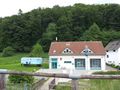
HP in the wood above the fire brigade
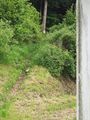
The way from a farm yard up into the wood


Achievements / Honorable Mention
Q-Owl earned the Land geohash achievement
|