Difference between revisions of "2014-05-12 49 8"
imported>Q-Owl (→Photos) |
imported>Q-Owl (image at the top (left)) |
||
| Line 2: | Line 2: | ||
[[Image:{{{image|IMAGE}}}|thumb|left]] | [[Image:{{{image|IMAGE}}}|thumb|left]] | ||
| − | + | Remove this section if you don't want an image at the top (left) of your report. | |
| − | Remove this section if you don't want an image at the top (left) of your report. | + | You should remove the "Image:" or "File:" tag from your image file name, |
| − | tag from your image file name, and replace the all upper-case word IMAGE in the above line. | + | and replace the all upper-case word IMAGE in the above line. |
And DON'T FORGET to add your expedition and the best photo you took to the gallery on the Main Page! We'd love to read your report, but that means we first have to discover it! :) | And DON'T FORGET to add your expedition and the best photo you took to the gallery on the Main Page! We'd love to read your report, but that means we first have to discover it! :) | ||
--> | --> | ||
| + | [[Image:Image2014-05-12-010.jpg|thumb|left]] | ||
{{meetup graticule | {{meetup graticule | ||
| lat=49 | | lat=49 | ||
| Line 62: | Line 63: | ||
| date = 2014-05-12 | | date = 2014-05-12 | ||
| name = Q-Owl | | name = Q-Owl | ||
| − | }} | + | }} |
| − | |||
| − | |||
| − | |||
| − | |||
| − | |||
| − | |||
| − | |||
| − | |||
| − | |||
| − | |||
| − | |||
<!-- =============== USEFUL CATEGORIES FOLLOW ================ --> | <!-- =============== USEFUL CATEGORIES FOLLOW ================ --> | ||
Revision as of 13:07, 15 May 2014

| Mon 12 May 2014 in 49,8: 49.7105412, 8.6512221 geohashing.info google osm bing/os kml crox |
Location
In the wood near Bensheim-Auerbach, the northern part of Bensheim, above the area of the fire brigade Hochstädten.
Participants
Plan
Drive to Hochstädten (in the east of Bensheim-Auerbach) after Work about 16:10. There might be a little footpath starting opposite to the "Fiesta" Restaurant and leading near the hashpoint.
Expedition
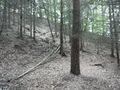
It was a little detour on my way home after ending with work a little bit earlier. I drove to Hochstädten, parked the car and had to look for, where the path into the wood might start. After crossing a farmyard opposite to the "Fiesta" restaurant I saw the path and went up into the wood until I reached the blind end of the path after 5 or ten minutes.
About 30 m above this place I tried to find the exact coordinates. A GPS dance on a >45° slope is not very easy and with trees and dark clouds over you. ...^^ But it's possible: Success. :-)
I found and marked the place, took some fotos and went/drove home. :-))
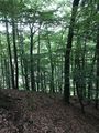
Photos
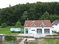
HP in the wood above the fire brigade
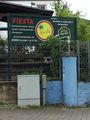
The "Fiesta" restaurant
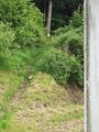
The path from a farm yard up into the wood
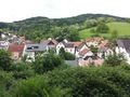
View over the Village from the wood
End of the path
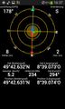
Proof
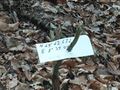
Mark

Grin
View to NW from the hash


Achievements / Honorable Mention
Q-Owl earned the Land geohash achievement
|