Difference between revisions of "2014-05-14 32 -117"
From Geohashing
imported>LucasBrown ([retro picture] Map at the hashpoint) |
imported>LucasBrown |
||
| Line 1: | Line 1: | ||
| + | {{meetup graticule | lat=32 | lon=-117 | date=2014-05-14}} | ||
| − | |||
| − | |||
| − | |||
| − | |||
| − | |||
| − | |||
| − | |||
| − | |||
| − | |||
| − | |||
| − | |||
| − | |||
| − | |||
| − | |||
| − | |||
| − | |||
__NOTOC__ | __NOTOC__ | ||
== Location == | == Location == | ||
| − | + | A bulldozed hilltop on the east end of the South Poway Business Park in Poway, CA | |
== Participants == | == Participants == | ||
| − | + | [[User:LucasBrown|LucasBrown]] | |
| − | |||
| − | |||
| − | |||
| − | |||
== Expedition == | == Expedition == | ||
| − | + | This expedition was made noteworthy by the visibility of the flames of one of the San Marcos components of the [http://en.wikipedia.org/wiki/May_2014_San_Diego_County_wildfires May 2014 San Diego wildfires]. | |
| − | |||
| − | |||
| − | |||
== Photos == | == Photos == | ||
| − | |||
| − | |||
| − | |||
<gallery perrow="5"> | <gallery perrow="5"> | ||
| − | |||
Image:2014-05-14_32_-117_LucasBrown_1400121907000.jpg | Geohash Droid details page at the hashpoint | Image:2014-05-14_32_-117_LucasBrown_1400121907000.jpg | Geohash Droid details page at the hashpoint | ||
| − | |||
Image:2014-05-14_32_-117_LucasBrown_1400121920000.jpg | Map at the hashpoint | Image:2014-05-14_32_-117_LucasBrown_1400121920000.jpg | Map at the hashpoint | ||
</gallery> | </gallery> | ||
| Line 46: | Line 19: | ||
== Achievements == | == Achievements == | ||
{{#vardefine:ribbonwidth|800px}} | {{#vardefine:ribbonwidth|800px}} | ||
| − | + | {{Consecutive geohash | count = 3 | latitude = 32 | longitude = -117 | date = 2014-05-12 | name = LucasBrown}} | |
| − | |||
| − | |||
| − | |||
| − | |||
| − | |||
| − | |||
| − | |||
| − | |||
| − | |||
| − | |||
| − | |||
| − | |||
| − | |||
[[Category:Expeditions]] | [[Category:Expeditions]] | ||
| − | |||
[[Category:Expeditions with photos]] | [[Category:Expeditions with photos]] | ||
| − | |||
| − | |||
| − | |||
| − | |||
| − | |||
[[Category:Coordinates reached]] | [[Category:Coordinates reached]] | ||
| − | |||
| − | |||
| − | |||
| − | |||
| − | |||
| − | |||
| − | |||
| − | |||
| − | |||
| − | |||
| − | |||
| − | |||
| − | |||
| − | |||
| − | |||
| − | |||
| − | |||
| − | |||
Revision as of 16:23, 11 June 2014
| Wed 14 May 2014 in 32,-117: 32.9399031, -117.0182449 geohashing.info google osm bing/os kml crox |
Location
A bulldozed hilltop on the east end of the South Poway Business Park in Poway, CA
Participants
Expedition
This expedition was made noteworthy by the visibility of the flames of one of the San Marcos components of the May 2014 San Diego wildfires.
Photos
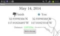
Geohash Droid details page at the hashpoint
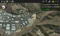
Map at the hashpoint


Achievements
LucasBrown earned the Consecutive geohash achievement
|