Difference between revisions of "2014-06-16 51 9"
From Geohashing
imported>GeorgDerReisende (create page) |
imported>GeorgDerReisende (expedition report added) |
||
| Line 1: | Line 1: | ||
| − | |||
| − | |||
| − | |||
| − | |||
| − | |||
| − | |||
| − | |||
| − | |||
| − | |||
| − | |||
{{meetup graticule | {{meetup graticule | ||
| lat=51 | | lat=51 | ||
| Line 18: | Line 8: | ||
__NOTOC__ | __NOTOC__ | ||
== Location == | == Location == | ||
| − | + | ||
| + | The hash lied in the fore garden of a private house in Eltmannshausen. | ||
== Participants == | == Participants == | ||
| − | + | ||
| − | + | [[User:GeorgDerReisende|GeorgDerReisende]] | |
== Plans == | == Plans == | ||
| − | + | ||
| + | The plan was to hitchhike there, collect the hash, and to hitchhike home. | ||
== Expedition == | == Expedition == | ||
| − | |||
| − | + | I started at about 11:00, hitchhiked to Eltmannshausen with one car, arrived there at 13:07, walked there around, only 107 meters, started to hitchhike home at 13:20, and arrived in Kassel at 15:29. | |
| − | |||
== Photos == | == Photos == | ||
| Line 38: | Line 28: | ||
--> | --> | ||
<gallery perrow="5"> | <gallery perrow="5"> | ||
| + | Image:2014-06-16 51 9 GeorgDerReisende 2104.jpg | the main street in Eltmannshausen | ||
| + | Image:2014-06-16 51 9 GeorgDerReisende 2107.jpg | the hash lied behind the hedge | ||
| + | Image:2014-06-16 51 9 GeorgDerReisende 2110.jpg | the proof | ||
| + | Image:2014-06-16 51 9 GeorgDerReisende 2111.jpg | view uphill | ||
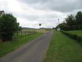
| + | Image:2014-06-16 51 9 GeorgDerReisende 2112.jpg | view downhill | ||
| + | Image:2014-06-16 51 9 GeorgDerReisende 2113.jpg | view back to the hash | ||
| + | Image:2014-06-16 51 9 GeorgDerReisende 2114.jpg | view to the geohasher | ||
</gallery> | </gallery> | ||
| Line 44: | Line 41: | ||
<!-- Add any achievement ribbons you earned below, or remove this section --> | <!-- Add any achievement ribbons you earned below, or remove this section --> | ||
| + | {{Thumbs Up | latitude = 51 | longitude = 9 | date = 2014-06-16 | name = GeorgDerReisende }} | ||
| − | + | [[Category:Expeditions]] | |
| − | |||
| − | [[Category: | ||
| − | + | [[Category:Expeditions with photos]] | |
| − | |||
| − | |||
| − | |||
| − | |||
| − | |||
| − | |||
| − | |||
| − | |||
| − | |||
| − | |||
| − | |||
| − | |||
| − | |||
| − | |||
[[Category:Coordinates reached]] | [[Category:Coordinates reached]] | ||
| − | |||
| − | |||
| − | |||
| − | |||
| − | |||
| − | |||
| − | |||
| − | |||
| − | |||
| − | |||
| − | |||
| − | |||
| − | |||
| − | |||
| − | |||
| − | |||
| − | |||
| − | |||
Revision as of 15:45, 16 June 2014
| Mon 16 Jun 2014 in 51,9: 51.1826021, 9.9878716 geohashing.info google osm bing/os kml crox |
Location
The hash lied in the fore garden of a private house in Eltmannshausen.
Participants
Plans
The plan was to hitchhike there, collect the hash, and to hitchhike home.
Expedition
I started at about 11:00, hitchhiked to Eltmannshausen with one car, arrived there at 13:07, walked there around, only 107 meters, started to hitchhike home at 13:20, and arrived in Kassel at 15:29.
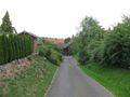
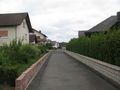
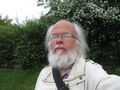
Photos
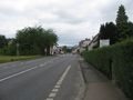
the main street in Eltmannshausen
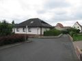
the hash lied behind the hedge
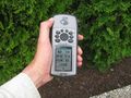
the proof
view uphill
view downhill
view back to the hash
view to the geohasher


Achievements
GeorgDerReisende earned the Thumbs Up Geohash Achievement
|