Difference between revisions of "2014-06-20 1 103"
From Geohashing
imported>Cyazlars |
imported>Cyazlars m |
||
| Line 18: | Line 18: | ||
TBC | TBC | ||
| − | |||
<gallery> | <gallery> | ||
Image:2014-06-20_1_103_Cyazlars_1403260003000.jpg | Coordinates reached! | Image:2014-06-20_1_103_Cyazlars_1403260003000.jpg | Coordinates reached! | ||
| − | Image:2014-06-20_1_103_Cyazlars_1403260767168.jpg | | + | Image:2014-06-20_1_103_Cyazlars_1403260767168.jpg | Clarke Quay |
| − | Image:2014-06-20_1_103_Cyazlars_1403260692130.jpg | | + | Image:2014-06-20_1_103_Cyazlars_1403260692130.jpg | Government building |
| + | |||
| + | Image:20140620_182820.jpg | Silly grin | ||
</gallery> | </gallery> | ||
| + | |||
| + | [[Category:Expeditions]] | ||
| + | [[Category:Expeditions with photos]] | ||
| + | [[Category:Coordinates reached]] | ||
Revision as of 14:04, 20 June 2014
| Fri 20 Jun 2014 in Singapore: 1.2904097, 103.8473062 geohashing.info google osm bing/os kml crox |
Contents
Location
Along River Valley Road, next to Clarke Quay.
Participants
Plans
Take a train to City Hall and walk to the hashpoint. And then maybe try to find a geocache nearby - apparently someone left one in the area just two days ago. I could go for an Honorable Mention, at least!
Expedition
TBC
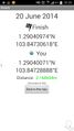
Coordinates reached!
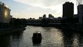
Clarke Quay
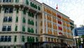
Government building

Silly grin


