Difference between revisions of "2014-06-27 66 25"
From Geohashing
imported>Isopekka (Created page with "thumb|left {{meetup graticule | lat=66 | lon=25 | date=2014-06-27 }} == Location == In Vennivaara, in a forest. == Participants == * User:...") |
imported>FippeBot m (Location) |
||
| Line 70: | Line 70: | ||
[[Category:Expeditions with photos]] | [[Category:Expeditions with photos]] | ||
[[Category:Coordinates reached]] | [[Category:Coordinates reached]] | ||
| + | {{location|FI|10}} | ||
Latest revision as of 00:34, 15 August 2019

| Fri 27 Jun 2014 in 66,25: 66.5474705, 25.5775200 geohashing.info google osm bing/os kml crox |
Contents
Location
In Vennivaara, in a forest.
Participants
Expedition
- Driving total 24 km
- Walking total 0.4 km
- Expedition took 1 h
- Physical effort (1-5): 1
Expedition started about at noon. The hashpoint situated near the forest road, I had to walk only about 200 meters.
Photos
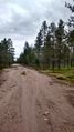
100 m to the Hash.
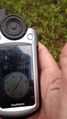
The Proof.
Woodpekka showing the exact Hash.
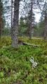
Near the Hash.


Achievements
isopekka earned the Land geohash achievement
|
Geohashing Expeditions and Plans on This Day
Expeditions and Plans
| 2014-06-27 | ||
|---|---|---|
| Mannheim, Germany | Q-Owl | In Viernheim, in front of the Bowling Center. |
| Warszawa West, Poland | Norill, Ziemba, Ziemek, Weronika | Dirt road in a forest near Stara Wrona (pol. Old Crow). |
| Rovaniemi, Finland | isopekka | In Vennivaara, in a forest. |