Difference between revisions of "2014-07-09 41 -88"
From Geohashing
imported>Dvdwinter9 (Created page with " <!-- If you did not specify these parameters in the template, please substitute appropriate values for IMAGE, LAT, LON, and DATE (YYYY-MM-DD format) Image:{{{image|IMAGE}...") |
imported>Dvdwinter9 |
||
| Line 34: | Line 34: | ||
== Photos == | == Photos == | ||
<gallery perrow="3"> | <gallery perrow="3"> | ||
| − | Image:2014_07_09_41_-88_mug.jpg | | + | Image:2014_07_09_41_-88_mug.jpg | Probably should have smiled |
Image:2014_07_09_41_-88_car.jpg | The steed | Image:2014_07_09_41_-88_car.jpg | The steed | ||
Image:2014_07_09_41_-88_proof.png | proof | Image:2014_07_09_41_-88_proof.png | proof | ||
Revision as of 04:15, 10 July 2014
| Wed 9 Jul 2014 in 41,-88: 41.7715284, -88.0661798 geohashing.info google osm bing/os kml crox |
Location
Southwest corner of Arnold Drive and 63rd Street, Woodridge, IL 60517
Participants
Plans
Decided to do this last-minute short trip when I saw it's so close to work. As in, I started writing this in my car. It's at an intersection in a subdivision so I won't stay long.
Expedition
My starting point was the empty parking lot of an abandoned K-Mart. Classy! Drive was pretty easy, only 8 miles by car. Pulled over and parked, walked to the coordinates and took some pictures. Pretty simple!
Tracklog
Photos

Probably should have smiled
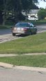
The steed
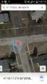
proof


