Difference between revisions of "2014-07-22 51 9"
From Geohashing
imported>GeorgDerReisende (new expedition) |
imported>GeorgDerReisende (expedition report added) |
||
| Line 1: | Line 1: | ||
| + | [[Image:{{{image|2014-07-22 51 9 GeorgDerReisende 3395.jpg}}}|thumb|left]] | ||
| − | |||
| − | |||
| − | |||
| − | |||
| − | |||
| − | |||
| − | |||
| − | |||
| − | |||
{{meetup graticule | {{meetup graticule | ||
| lat=51 | | lat=51 | ||
| Line 18: | Line 10: | ||
__NOTOC__ | __NOTOC__ | ||
== Location == | == Location == | ||
| − | + | ||
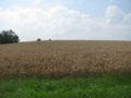
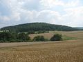
| + | The hash lied in a field above of Niddawitzhausen. | ||
== Participants == | == Participants == | ||
| − | + | ||
| − | + | [[User:GeorgDerReisende|GeorgDerReisende]] | |
== Plans == | == Plans == | ||
| − | + | ||
| + | Hitchhiking and walking. | ||
== Expedition == | == Expedition == | ||
| − | |||
| − | + | There were too many grains on the field. Not reached. | |
| − | |||
== Photos == | == Photos == | ||
| Line 38: | Line 30: | ||
--> | --> | ||
<gallery perrow="5"> | <gallery perrow="5"> | ||
| + | Image:2014-07-22 51 9 GeorgDerReisende 3381.jpg | view to Reichensachsen | ||
| + | Image:2014-07-22 51 9 GeorgDerReisende 3383.jpg | view to the valley of the river Werra | ||
| + | Image:2014-07-22 51 9 GeorgDerReisende 3385.jpg | 500 meters to # | ||
| + | Image:2014-07-22 51 9 GeorgDerReisende 3395.jpg | # is 40 meters too far | ||
| + | Image:2014-07-22 51 9 GeorgDerReisende 3402.jpg | proof of dance | ||
| + | Image:2014-07-22 51 9 GeorgDerReisende 3404.jpg | from the other side | ||
| + | Image:2014-07-22 51 9 GeorgDerReisende 3407.jpg | Niddawitzhausen | ||
</gallery> | </gallery> | ||
| − | |||
| − | |||
| − | |||
| − | |||
| − | |||
| − | |||
| − | |||
| − | |||
| − | |||
| − | |||
| − | |||
| − | |||
| − | |||
| − | |||
| − | |||
| − | |||
| − | |||
[[Category:Expeditions]] | [[Category:Expeditions]] | ||
| − | |||
| − | |||
| − | |||
| − | |||
| − | |||
| − | |||
| − | |||
| − | |||
| + | [[Category:Coordinates not reached]] | ||
| − | |||
| − | |||
| − | |||
| − | |||
[[Category:Not reached - Mother Nature]] | [[Category:Not reached - Mother Nature]] | ||
| − | |||
| − | |||
| − | |||
| − | |||
| − | |||
| − | |||
| − | |||
| − | |||
| − | |||
| − | |||
| − | |||
Revision as of 15:43, 22 July 2014

| Tue 22 Jul 2014 in 51,9: 51.1680926, 9.9767462 geohashing.info google osm bing/os kml crox |
Location
The hash lied in a field above of Niddawitzhausen.
Participants
Plans
Hitchhiking and walking.
Expedition
There were too many grains on the field. Not reached.
Photos
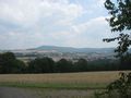
view to Reichensachsen
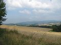
view to the valley of the river Werra
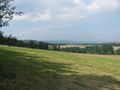
500 meters to #
- is 40 meters too far
proof of dance
from the other side
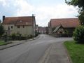
Niddawitzhausen


