Difference between revisions of "2014-09-12 60 24"
imported>Nebini |
imported>Nebini (separate stories) |
||
| Line 22: | Line 22: | ||
== Participants == | == Participants == | ||
* [[User:Nebini|Nebini]] | * [[User:Nebini|Nebini]] | ||
| + | * [[User:Pastori|Pastori]] | ||
== Plans == | == Plans == | ||
| − | Should be easy. There is a place to park a car 500 meters from the hash and only the last 100 meters should be on the swamp. | + | === Nebini's plans === |
| + | Should be easy to reach after a work day. There is a place to park a car 500 meters from the hash and only the last 100 meters should be on the swamp. | ||
== Expedition == | == Expedition == | ||
| + | |||
| + | === Nebini's report === | ||
[[Image: 2014-09-21 60 24 Route from road 51.png | thumb | right | Route used by Nebini]] | [[Image: 2014-09-21 60 24 Route from road 51.png | thumb | right | Route used by Nebini]] | ||
Another swamp expedition, like the 3 previous hashes which I did reach :) | Another swamp expedition, like the 3 previous hashes which I did reach :) | ||
| − | After turning off the road 51 I followed 2 other cars to the Drusibackantie, noticed the missign sign and thought that it must mean "No thoroughfare to Peuramaa golf". Getting near was straightforward, just typical small residential road. On the other end the sign appeared to " | + | After turning off the road 51 I followed 2 other cars to the Drusibackantie, noticed the missign sign and thought that it must mean "No thoroughfare to Peuramaa golf". Getting near was straightforward, just typical small residential road. On the other end of throad the sign appeared to indicate "service access only". Since I was now on a permissible road, I thought, parked the car. After leaving the car and walking along the Helsinki-Hanko highway 51 on the other side of the wall. Things looked this will only take like 5 minutes. After wandering off the paved roadside the ground turned unstable. |
First 50 meters off the wall were easy. Then the swamp started.. | First 50 meters off the wall were easy. Then the swamp started.. | ||
| − | The swamp was kind of unusual, I'm used to see such swamps only near the coastlines, long reeds and no haircap moss. This swamp was not a korpi type swamp as I thought when planning the expedition. A cross between letto and luhta types swamps would be more correct. This | + | The swamp was kind of unusual, I'm used to see such swamps only near the coastlines, long reeds and no haircap moss. This swamp was not a korpi type swamp as I thought when planning the expedition. A cross between letto and luhta types swamps would be more correct. This equates to much more water than I expected. Fortunately I brought wellingtons with me. The last 30 meters took over 15 minutes because finding suitable footing was tricky at times and I had to turn back few times to search for a route with not so much water. |
The haspoint was located on a not so wet island in the center of the swamp. On the island and around the area there were many depressions and paths where mooses have spent time. Few moose droppings were also found. | The haspoint was located on a not so wet island in the center of the swamp. On the island and around the area there were many depressions and paths where mooses have spent time. Few moose droppings were also found. | ||
| Line 44: | Line 48: | ||
== Videos == | == Videos == | ||
| − | [https://www.youtube.com/watch?v=IoKB0uYsb44 | + | Nebini's view on [https://www.youtube.com/watch?v=IoKB0uYsb44 walking back to the road]. |
== Photos == | == Photos == | ||
| + | === Pastori's photos === | ||
<gallery perrow="5"> | <gallery perrow="5"> | ||
| Line 55: | Line 60: | ||
</gallery> | </gallery> | ||
| + | === Nebini's photos === | ||
<gallery perrow="5"> | <gallery perrow="5"> | ||
Image: 2014-09-21 60 24 No motor vehicles.JPG | No motor vehicles past this point. Notice the missign sign. | Image: 2014-09-21 60 24 No motor vehicles.JPG | No motor vehicles past this point. Notice the missign sign. | ||
| Line 85: | Line 91: | ||
[[Category:Coordinates reached]] | [[Category:Coordinates reached]] | ||
| + | [[Category:Coordinates not reached]] | ||
Revision as of 21:35, 12 September 2014
| Fri 12 Sep 2014 in 60,24: 60.1145202, 24.4651157 geohashing.info google osm bing/os kml crox |
Location
On a swamp with some trees and low undergrowth. less than 200 meters from a highway. Kirkkonummi, Espoo.
Participants
Plans
Nebini's plans
Should be easy to reach after a work day. There is a place to park a car 500 meters from the hash and only the last 100 meters should be on the swamp.
Expedition
Nebini's report

Another swamp expedition, like the 3 previous hashes which I did reach :)
After turning off the road 51 I followed 2 other cars to the Drusibackantie, noticed the missign sign and thought that it must mean "No thoroughfare to Peuramaa golf". Getting near was straightforward, just typical small residential road. On the other end of throad the sign appeared to indicate "service access only". Since I was now on a permissible road, I thought, parked the car. After leaving the car and walking along the Helsinki-Hanko highway 51 on the other side of the wall. Things looked this will only take like 5 minutes. After wandering off the paved roadside the ground turned unstable.
First 50 meters off the wall were easy. Then the swamp started..
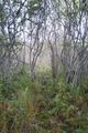
The swamp was kind of unusual, I'm used to see such swamps only near the coastlines, long reeds and no haircap moss. This swamp was not a korpi type swamp as I thought when planning the expedition. A cross between letto and luhta types swamps would be more correct. This equates to much more water than I expected. Fortunately I brought wellingtons with me. The last 30 meters took over 15 minutes because finding suitable footing was tricky at times and I had to turn back few times to search for a route with not so much water.
The haspoint was located on a not so wet island in the center of the swamp. On the island and around the area there were many depressions and paths where mooses have spent time. Few moose droppings were also found.
Getting back to the road took around 10 minutes. A stick to probe the water would have been a helpful accessory.
When driving back I didn't notice the third sign which stopped Pastori from approaching the hashpoint.
Videos
Nebini's view on walking back to the road.
Photos
Pastori's photos
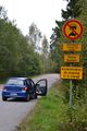
The signs that thwarted Pastori from this hashpoint. See for more information.

Pastori waving goodbye to the hashpoint, that is situated on the other side of the motorway fence.
This close Pastori got.


Nebini's photos

No motor vehicles past this point. Notice the missign sign.

Other end of the shortcut. Notice the sign.

Parking. The wall was built on 2011.

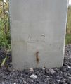
Spotted broken sign for a local train

A lake and dense vegetation. Should be easy.

A depression on the ground. A moose has probably slept here.

Ground was getting wet

Tall reeds

Wellingtons were necessary
Only water

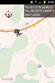
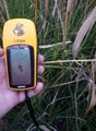
Proof

Exhausted pose
A detail on the pedestal of a roadsign


