Difference between revisions of "2014-09-16 49 8"
imported>DODO (→Photos) |
imported>FippeBot m (Location) |
||
| Line 70: | Line 70: | ||
[[Category:Expeditions with photos]] | [[Category:Expeditions with photos]] | ||
[[Category:Coordinates reached]] | [[Category:Coordinates reached]] | ||
| + | {{location|DE|BW|HD}} | ||
Latest revision as of 01:27, 15 August 2019
| Tue 16 Sep 2014 in 49,8: 49.2858128, 8.5814758 geohashing.info google osm bing/os kml crox |
Location
At the edge of a small forest between Reilingen and the St. Leoner lake.
Participants
Plans
To go there on my way to work. I have to go to work by car today, but it's just 12 KM farer than my usual way.
Expedition
I had to take a different way to work than usual to come to the hash , and I immediately remembered why I usually don't use this route: there's always a traffic jam before the Speyerer bridge at this time. After I went through that, the drive was uneventful. Soon I reached the parking place near the St. Leoner lake.
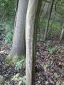
From here it was just a short (~500 m) and nice walk to the hash, including a 70m part through a light forest. To my surprise the hash lies directly on a small path that I reached 5 m from it. I took some photos, left a chalk mark and wanted to go back to the car using the new spotted path. But just 20 m from the hash the path gets quite impassable being overgrown by blackberries. So I turned around and tried the path in the other direction, but also some 20 m behind the hash the path vanished. It's really a hashpath, just leading 20 m in any direction of todays hash (maybe it will vanish at midnight?).
Tracklog
Photos
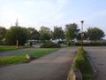
here I parked the car
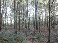
70 m in there...
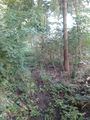
... on this mysterious path...
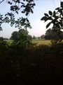
... and next to this lawn...
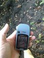
...lies a hashpoint...

... celebrated with a grin...
...and marked with chalk


Achievements
DODO earned the Land geohash achievement
|