Difference between revisions of "2014-10-12 51 13"
imported>Oisín |
imported>Oisín |
||
| Line 5: | Line 5: | ||
| date=2014-10-12 | | date=2014-10-12 | ||
}} | }} | ||
| − | |||
| − | |||
__NOTOC__ | __NOTOC__ | ||
== Location == | == Location == | ||
| Line 23: | Line 21: | ||
== Expedition == | == Expedition == | ||
<!-- how it all turned out. your narrative goes here. --> | <!-- how it all turned out. your narrative goes here. --> | ||
| − | + | After lunch I decided to do a little tour by bike to Moritzburg which would let me reach the hash on my way. The coordinates could be reached about 20m off the path on a meadow on the southern border of a forest. Thus getting to the exact coordinates was no problem at all. After taking a picture and logging my visit on the expedition page I continued to Moritzburg castle and returned home along small roads. Overall my trip was about 29km. The weather was sunny at about 18-20°C. | |
Revision as of 07:43, 13 October 2014
| Sun 12 Oct 2014 in 51,13: 51.1397938, 13.6905856 geohashing.info google osm bing/os kml crox |
Location
Forest between Dresden and Moritzburg
Participants
Plans
I might be going to Moritzburg by bike on Sunday afternoon. If I do, I'll try to visit this hash on my way back.
Expedition
After lunch I decided to do a little tour by bike to Moritzburg which would let me reach the hash on my way. The coordinates could be reached about 20m off the path on a meadow on the southern border of a forest. Thus getting to the exact coordinates was no problem at all. After taking a picture and logging my visit on the expedition page I continued to Moritzburg castle and returned home along small roads. Overall my trip was about 29km. The weather was sunny at about 18-20°C.
- Reached hash by bike in sunny weather. -- Oisín (talk) @51.1398,13.6906 14:06, 12 October 2014 (CEST)
Tracklog
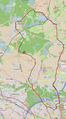
Track of my cycling tour (around 29km). The hash is marked by a star.

Photos
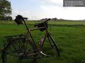
My bike looking southward. @51.1398,13.6906

Achievements
- Land geohash
- Bike geohash