Difference between revisions of "2014-11-03 47 -122"
From Geohashing
imported>Thomcat (Rain. [http://www.openstreetmap.org/?lat=47.82093542&lon=-122.28167674&zoom=16&layers=B000FTF @47.8209,-122.2817]) |
imported>Thomcat ([live picture] img from 12m; geohashdroid says 42m [http://www.openstreetmap.org/?lat=47.82950000&lon=-122.32600000&zoom=16&layers=B000FTF @47.8295,-122.3260]) |
||
| Line 30: | Line 30: | ||
Image:2014-11-03_47_-122_thomcat_-1.jpg | Rain. [http://www.openstreetmap.org/?lat=47.82093542&lon=-122.28167674&zoom=16&layers=B000FTF @47.8209,-122.2817] | Image:2014-11-03_47_-122_thomcat_-1.jpg | Rain. [http://www.openstreetmap.org/?lat=47.82093542&lon=-122.28167674&zoom=16&layers=B000FTF @47.8209,-122.2817] | ||
| + | |||
| + | Image:2014-11-03_47_-122_thomcat_1415059066661.jpg | img from 12m; geohashdroid says 42m [http://www.openstreetmap.org/?lat=47.82950000&lon=-122.32600000&zoom=16&layers=B000FTF @47.8295,-122.3260] | ||
</gallery> | </gallery> | ||
Revision as of 23:59, 3 November 2014
| Mon 3 Nov 2014 in Seattle: 47.8293835, -122.3265310 geohashing.info google osm bing/os kml crox |
Location
Someones front yard off Blue Ridge Drive in Lynnwood.
Participants
Plans
Stop by after work, early afternoon. Examine how their Blue Ridge compares to the one I live near. Issue a Lynnwood challenge for A Tale of Two Hashes (very surprised there wasn't one).
Expedition
Tracklog
Photos
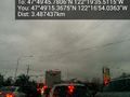
Rain. @47.8209,-122.2817
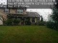
img from 12m; geohashdroid says 42m @47.8295,-122.3260


Achievements