Difference between revisions of "2014-11-04 47 8"
imported>Chris 47 8 m |
imported>Chris 47 8 (pics and exp added) |
||
| Line 1: | Line 1: | ||
| − | |||
| − | |||
| − | |||
| − | |||
| − | |||
| − | |||
| − | |||
| − | |||
| − | |||
{{meetup graticule | {{meetup graticule | ||
| lat=47 | | lat=47 | ||
| Line 15: | Line 6: | ||
}} | }} | ||
| − | |||
__NOTOC__ | __NOTOC__ | ||
== Location == | == Location == | ||
| Line 22: | Line 12: | ||
== Participants == | == Participants == | ||
*[[User:Chris 47 8|Chris 47 8]] | *[[User:Chris 47 8|Chris 47 8]] | ||
| − | |||
== Plans == | == Plans == | ||
| Line 28: | Line 17: | ||
== Expedition == | == Expedition == | ||
| − | + | Todays hash lied just a few hundred meters from a bus stop, pretty easy to reach. And it was very close to a medieval castle just above the town of Elgg. So i went there, maybe i could get a glimpse into the castle. | |
| + | Unfortunately, the castle turned out to be private property and inaccessible to public. And even worse, the tavern just in front of it was also closed. So i just walked into the field where the hash was, got the coordinates, and went back home without seeing anything exciting. Too bad! | ||
== Tracklog == | == Tracklog == | ||
| − | + | no | |
== Photos == | == Photos == | ||
| − | < | + | <gallery perrow="3"> |
| − | Image: | + | Image:2014110447801.JPG|The castle is private property. |
| − | + | Image:2014110447802.JPG|The castle tavern was closed. | |
| − | + | Image:2014110447803.PNG|Coordinates reached. | |
| + | Image:2014110447804.JPG|My grey backpack indicates the hashpoint. | ||
| + | Image:2014110447805.JPG|For the cattle. | ||
| + | Image:2014110447806.JPG|Autumn shades. | ||
</gallery> | </gallery> | ||
== Achievements == | == Achievements == | ||
{{#vardefine:ribbonwidth|800px}} | {{#vardefine:ribbonwidth|800px}} | ||
| − | |||
| − | |||
| − | |||
| − | |||
| − | |||
| − | |||
| − | |||
| − | |||
| − | |||
| − | |||
| − | |||
| − | |||
| − | |||
| − | |||
[[Category:Expeditions]] | [[Category:Expeditions]] | ||
| − | |||
[[Category:Expeditions with photos]] | [[Category:Expeditions with photos]] | ||
| − | |||
| − | |||
| − | |||
| − | |||
| − | |||
[[Category:Coordinates reached]] | [[Category:Coordinates reached]] | ||
| − | |||
| − | |||
| − | |||
| − | |||
| − | |||
| − | |||
| − | |||
| − | |||
| − | |||
| − | |||
| − | |||
| − | |||
| − | |||
| − | |||
| − | |||
| − | |||
| − | |||
| − | |||
Revision as of 17:18, 4 November 2014
| Tue 4 Nov 2014 in 47,8: 47.4814505, 8.8677742 geohashing.info google osm bing/os kml crox |
Location
Close to Castle Elgg.
Participants
Plans
Bus 680 from Winterthur leaving 12:43 will bring me directly to the hash.
Expedition
Todays hash lied just a few hundred meters from a bus stop, pretty easy to reach. And it was very close to a medieval castle just above the town of Elgg. So i went there, maybe i could get a glimpse into the castle. Unfortunately, the castle turned out to be private property and inaccessible to public. And even worse, the tavern just in front of it was also closed. So i just walked into the field where the hash was, got the coordinates, and went back home without seeing anything exciting. Too bad!
Tracklog
no
Photos
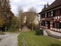
The castle is private property.
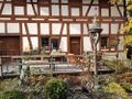
The castle tavern was closed.

Coordinates reached.
My grey backpack indicates the hashpoint.
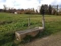
For the cattle.
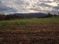
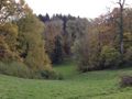
Autumn shades.


