Difference between revisions of "2014-12-16 51 9"
imported>GeorgDerReisende (create page) |
imported>GeorgDerReisende (expedition report for Moringen-Behrensen) |
||
| Line 1: | Line 1: | ||
| − | |||
| − | |||
| − | |||
| − | |||
| − | |||
| − | |||
| − | |||
| − | |||
| − | |||
| − | |||
{{meetup graticule | {{meetup graticule | ||
| lat=51 | | lat=51 | ||
| Line 18: | Line 8: | ||
__NOTOC__ | __NOTOC__ | ||
== Location == | == Location == | ||
| − | + | ||
| + | The hash lay on the edge of a field at Behrensen. | ||
== Participants == | == Participants == | ||
| − | + | ||
| − | + | [[User:GeorgDerReisende|GeorgDerReisende]] | |
== Plans == | == Plans == | ||
| − | + | ||
| + | I planned to hitchhike to the junction Nörten-Hardenberg and to walk from there to the hash and back to the motorway. | ||
== Expedition == | == Expedition == | ||
| − | |||
| − | + | I started at home at 11 o'clock, I started to hitchhike at 11:30. Within a minute I got a lift. After talking with the driver about my today's job, he decided to bring me to the small village. So I arrived at Behrensen at 11:58! I walked to the hash and made the usual deeds. Then I walked back to the village and looked for ways to walk for home. I found a small shelter, where I made a short stop and took a frugal meal. Then I decided not to take the shortest way but another one and found three ways not shown on OSM. At least I arrived at Nörten's junction at 14:40, waited there 40 minutes for a lift and at Göttingen's junction I had to wait another ten minutes. I arrived at Kassel at 16.10. | |
| − | |||
== Photos == | == Photos == | ||
| − | |||
| − | |||
| − | |||
<gallery perrow="5"> | <gallery perrow="5"> | ||
| + | Image:2014-12-16 51 9 GeorgDerReisende 1001.jpg | Arrived at Behrensen. | ||
| + | Image:2014-12-16 51 9 GeorgDerReisende 1021.jpg | Way to hash. | ||
| + | Image:2014-12-16 51 9 GeorgDerReisende 1022.jpg | On this small bridge. | ||
| + | Image:2014-12-16 51 9 GeorgDerReisende 1025.jpg | Proof. | ||
| + | Image:2014-12-16 51 9 GeorgDerReisende 1026.jpg | Dance. | ||
| + | Image:2014-12-16 51 9 GeorgDerReisende 1027.jpg | The south. | ||
| + | Image:2014-12-16 51 9 GeorgDerReisende 1028.jpg | The west. | ||
| + | Image:2014-12-16 51 9 GeorgDerReisende 1029.jpg | The north. | ||
| + | Image:2014-12-16 51 9 GeorgDerReisende 1030.jpg | The east. | ||
| + | Image:2014-12-16 51 9 GeorgDerReisende 1031.jpg | Behind the village there is the motorway. | ||
| + | Image:2014-12-16 51 9 GeorgDerReisende 1034.jpg | The geohasher. | ||
| + | Image:2014-12-16 51 9 GeorgDerReisende 1067.jpg | The shop is closed and another shop is open. | ||
| + | Image:2014-12-16 51 9 GeorgDerReisende 1089.jpg | The shelter. | ||
| + | Image:2014-12-16 51 9 GeorgDerReisende 1095.jpg | Cake and juice. | ||
| + | Image:2014-12-16 51 9 GeorgDerReisende 1094.jpg | View to Behrensen. | ||
</gallery> | </gallery> | ||
| Line 44: | Line 46: | ||
<!-- Add any achievement ribbons you earned below, or remove this section --> | <!-- Add any achievement ribbons you earned below, or remove this section --> | ||
| + | {{Thumbs Up | latitude = 51 | longitude = 9 | date = 2014-12-16 | name = GeorgDerReisende }} | ||
| − | + | [[Category:Expeditions]] | |
| − | |||
| − | [[Category: | ||
| − | + | [[Category:Expeditions with photos]] | |
| − | |||
| − | |||
| − | |||
| − | [[Category: | ||
| − | |||
| − | |||
| − | |||
| − | |||
| − | |||
| − | |||
| − | |||
| − | |||
| − | |||
| − | |||
[[Category:Coordinates reached]] | [[Category:Coordinates reached]] | ||
| − | |||
| − | |||
| − | |||
| − | |||
| − | |||
| − | |||
| − | |||
| − | |||
| − | |||
| − | |||
| − | |||
| − | |||
| − | |||
| − | |||
| − | |||
| − | |||
| − | |||
| − | |||
Revision as of 17:33, 16 December 2014
| Tue 16 Dec 2014 in 51,9: 51.6566782, 9.8972751 geohashing.info google osm bing/os kml crox |
Location
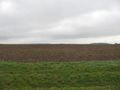
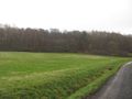
The hash lay on the edge of a field at Behrensen.
Participants
Plans
I planned to hitchhike to the junction Nörten-Hardenberg and to walk from there to the hash and back to the motorway.
Expedition
I started at home at 11 o'clock, I started to hitchhike at 11:30. Within a minute I got a lift. After talking with the driver about my today's job, he decided to bring me to the small village. So I arrived at Behrensen at 11:58! I walked to the hash and made the usual deeds. Then I walked back to the village and looked for ways to walk for home. I found a small shelter, where I made a short stop and took a frugal meal. Then I decided not to take the shortest way but another one and found three ways not shown on OSM. At least I arrived at Nörten's junction at 14:40, waited there 40 minutes for a lift and at Göttingen's junction I had to wait another ten minutes. I arrived at Kassel at 16.10.
Photos
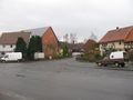
Arrived at Behrensen.
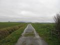
Way to hash.

On this small bridge.
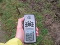
Proof.

Dance.

The south.

The west.
The north.

The east.

Behind the village there is the motorway.

The geohasher.

The shop is closed and another shop is open.
The shelter.

Cake and juice.

View to Behrensen.


Achievements
GeorgDerReisende earned the Thumbs Up Geohash Achievement
|