Difference between revisions of "2015-01-18 51 9"
imported>GeorgDerReisende (create page) |
imported>GeorgDerReisende (expedition report for) |
||
| Line 1: | Line 1: | ||
| − | |||
| − | |||
| − | |||
| − | |||
| − | |||
| − | |||
| − | |||
| − | |||
| − | |||
| − | |||
{{meetup graticule | {{meetup graticule | ||
| lat=51 | | lat=51 | ||
| Line 18: | Line 8: | ||
__NOTOC__ | __NOTOC__ | ||
== Location == | == Location == | ||
| − | + | ||
| + | The hash lay on a field in Baunatal-Großenritte. | ||
== Participants == | == Participants == | ||
| − | + | ||
| − | + | [[User:GeorgDerReisende|GeorgDerReisende]] | |
== Plans == | == Plans == | ||
| − | + | ||
| + | I wanted to travel by tramway to Großenritte and then to walk to the hash. | ||
== Expedition == | == Expedition == | ||
| − | + | ||
| + | I left home at 10:15. I took the trams 3 and 5 to Großenritte and arrived there at 11:15. I had 1 ¼ km to walk. Coming nearer to the hash I found a construction site, later I saw it only beyond the hash. | ||
| + | |||
| + | The hash itself lay on a ploughed field. Eleven meters to go. Usually I don't walk onto such fields, but today the ground was a little bit frozen, so I tried it. After five meters, the cells of my camera ran out of energy. Standing on the field, I changed the batteries. Five meters later I danced around and just at the moment, when I saw the zero mark, the cells ran out again. Again, I changed the batteries. I could take some photos and again the cells ran out. While I made the photo of the grin. Maybe, because the grin wasn't really a grin, the camera didn't take it. And I had no more fresh loaded cells to take more photos. On the way home I realized, that there were running cells in the GPS, and those I used for taking some photos while walking home. | ||
== Tracklog == | == Tracklog == | ||
| Line 38: | Line 33: | ||
--> | --> | ||
<gallery perrow="5"> | <gallery perrow="5"> | ||
| + | Image:2015-01-18 51 9 GeorgDerReisende 1376.jpg | the terminus of the tramway at Großenritte | ||
| + | Image:2015-01-18 51 9 GeorgDerReisende 1383.jpg | the construction site, the hash right and behind the blue containers | ||
| + | Image:2015-01-18 51 9 GeorgDerReisende 1385.jpg | nearly proof | ||
| + | Image:2015-01-18 51 9 GeorgDerReisende 1386.jpg | the north | ||
| + | Image:2015-01-18 51 9 GeorgDerReisende 1387.jpg | the west | ||
| + | Image:2015-01-18 51 9 GeorgDerReisende 1388.jpg | the east | ||
| + | Image:2015-01-18 51 9 GeorgDerReisende 1389.jpg | the south | ||
| + | Image:2015-01-18 51 9 GeorgDerReisende 1390.jpg | view to Baunatal | ||
| + | Image:2015-01-18 51 9 GeorgDerReisende 1396.jpg | another view to the hash | ||
| + | Image:2015-01-18 51 9 GeorgDerReisende 1426.jpg | looking back on the way home I saw something blue in the distance | ||
</gallery> | </gallery> | ||
| Line 44: | Line 49: | ||
<!-- Add any achievement ribbons you earned below, or remove this section --> | <!-- Add any achievement ribbons you earned below, or remove this section --> | ||
| + | {{land geohash | latitude = 51 | longitude = 9 | date = 2015-01-18 | name = GeorgDerReisende }} | ||
| − | + | [[Category:Expeditions]] | |
| − | |||
| − | [[Category: | ||
| − | + | [[Category:Expeditions with photos]] | |
| − | |||
| − | |||
| − | |||
| − | [[Category: | ||
| − | |||
| − | |||
| − | |||
| − | |||
| − | |||
| − | |||
| − | |||
| − | |||
| − | |||
| − | |||
[[Category:Coordinates reached]] | [[Category:Coordinates reached]] | ||
| − | |||
| − | |||
| − | |||
| − | |||
| − | |||
| − | |||
| − | |||
| − | |||
| − | |||
| − | |||
| − | |||
| − | |||
| − | |||
| − | |||
| − | |||
| − | |||
| − | |||
| − | |||
Revision as of 14:02, 18 January 2015
| Sun 18 Jan 2015 in 51,9: 51.2551586, 9.3731073 geohashing.info google osm bing/os kml crox |
Location
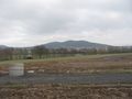
The hash lay on a field in Baunatal-Großenritte.
Participants
Plans
I wanted to travel by tramway to Großenritte and then to walk to the hash.
Expedition
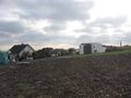
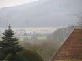
I left home at 10:15. I took the trams 3 and 5 to Großenritte and arrived there at 11:15. I had 1 ¼ km to walk. Coming nearer to the hash I found a construction site, later I saw it only beyond the hash.
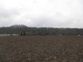
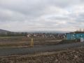
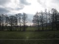
The hash itself lay on a ploughed field. Eleven meters to go. Usually I don't walk onto such fields, but today the ground was a little bit frozen, so I tried it. After five meters, the cells of my camera ran out of energy. Standing on the field, I changed the batteries. Five meters later I danced around and just at the moment, when I saw the zero mark, the cells ran out again. Again, I changed the batteries. I could take some photos and again the cells ran out. While I made the photo of the grin. Maybe, because the grin wasn't really a grin, the camera didn't take it. And I had no more fresh loaded cells to take more photos. On the way home I realized, that there were running cells in the GPS, and those I used for taking some photos while walking home.
Tracklog
Photos
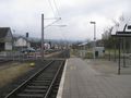
the terminus of the tramway at Großenritte
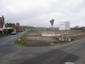
the construction site, the hash right and behind the blue containers
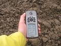
nearly proof
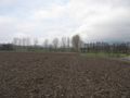
the north
the west
the east
the south
view to Baunatal
another view to the hash
looking back on the way home I saw something blue in the distance


Achievements
GeorgDerReisende earned the Land geohash achievement
|