Difference between revisions of "2015-01-27 47 -122"
From Geohashing
imported>Thomcat ([live picture] [http://www.openstreetmap.org/?lat=47.84118900&lon=-122.18468339&zoom=16&layers=B000FTF @47.8412,-122.1847]) |
imported>Thomcat ([live picture] Off leash dog area [http://www.openstreetmap.org/?lat=47.84131628&lon=-122.18368899&zoom=16&layers=B000FTF @47.8413,-122.1837]) |
||
| Line 40: | Line 40: | ||
Image:2015-01-27_47_-122_thomcat_1422377963648.jpg | [http://www.openstreetmap.org/?lat=47.84118900&lon=-122.18468339&zoom=16&layers=B000FTF @47.8412,-122.1847] | Image:2015-01-27_47_-122_thomcat_1422377963648.jpg | [http://www.openstreetmap.org/?lat=47.84118900&lon=-122.18468339&zoom=16&layers=B000FTF @47.8412,-122.1847] | ||
| + | |||
| + | Image:2015-01-27_47_-122_thomcat_1422378130240.jpg | Off leash dog area [http://www.openstreetmap.org/?lat=47.84131628&lon=-122.18368899&zoom=16&layers=B000FTF @47.8413,-122.1837] | ||
</gallery> | </gallery> | ||
Revision as of 17:03, 27 January 2015
| Tue 27 Jan 2015 in Seattle: 47.8411961, -122.1846586 geohashing.info google osm bing/os kml crox |
Location
Northwest section of Tambark Creek Park, off 35th Ave SE near Mill Creek.
Participants
Plans
Quick stop in the morning to survey the scene. Possible return (meetup?) in the afternoon.
Expedition
Tracklog
Photos
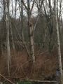
Woodpecker @47.8412,-122.1844
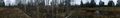
Panorama @47.8412,-122.1847
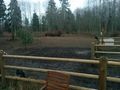
Off leash dog area @47.8413,-122.1837


Achievements