Difference between revisions of "2015-03-01 42 -78"
imported>Pedalpusher (new expedition report for Sunday) |
imported>Pedalpusher (updated categories) |
||
| Line 25: | Line 25: | ||
== Ribbons == | == Ribbons == | ||
| − | + | ||
{{land geohash | {{land geohash | ||
| latitude = 42 | | latitude = 42 | ||
| longitude = -78 | | longitude = -78 | ||
| − | | date = 2015- | + | | date = 2015-03-01 |
}} | }} | ||
| − | |||
| − | [[Category: | + | [[Category:Expeditions]] |
| + | [[Category:Coordinates reached]] | ||
| + | [[Category:Expeditions with photos]] | ||
Revision as of 18:48, 1 March 2015
| Sun 1 Mar 2015 in 42,-78: 42.9960394, -78.8743223 geohashing.info google osm bing/os kml crox |
Location
Tonawanda, NY - On the Sidewalk on Delaware Ave by the I-290
Participants
Plans
Since the hash is up in the NE corner for Sunday, I was really considering the SW graticule to add to my Minesweeper ribbon but it is on private property and I don't want to drive over an hour for nothing. There will be other opportunities for that graticule and this hash is right on the sidewalk on Delaware right by the I-290. I will drive up and park in a parking lot by the 290 and walk over on the sidewalk to the hash. Since the hash is right at the end of the guard rail, I should be able to get there without the GPS but I will bring it just in case the snow banks are covering the guard rail and I can't easily find the hash.
Expedition
Photos
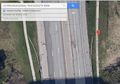
Satellite view of the hash. The question is...will I find the guard rail in the snow?

Ribbons
This user earned the Land geohash achievement
|