Difference between revisions of "2015-03-24 47 -122"
From Geohashing
imported>Thomcat ([live picture] [http://www.openstreetmap.org/?lat=47.80680660&lon=-122.35657755&zoom=16&layers=B000FTF @47.8068,-122.3566]) |
imported>Thomcat ([live picture] [http://www.openstreetmap.org/?lat=47.80687271&lon=-122.35667911&zoom=16&layers=B000FTF @47.8069,-122.3567]) |
||
| Line 38: | Line 38: | ||
Image:2015-03-24_47_-122_thomcat_1427238310479.jpg | [http://www.openstreetmap.org/?lat=47.80680660&lon=-122.35657755&zoom=16&layers=B000FTF @47.8068,-122.3566] | Image:2015-03-24_47_-122_thomcat_1427238310479.jpg | [http://www.openstreetmap.org/?lat=47.80680660&lon=-122.35657755&zoom=16&layers=B000FTF @47.8068,-122.3566] | ||
| + | |||
| + | Image:2015-03-24_47_-122_thomcat_1427238320086.jpg | [http://www.openstreetmap.org/?lat=47.80687271&lon=-122.35667911&zoom=16&layers=B000FTF @47.8069,-122.3567] | ||
</gallery> | </gallery> | ||
Revision as of 23:06, 24 March 2015
| Tue 24 Mar 2015 in Seattle: 47.8068621, -122.3566739 geohashing.info google osm bing/os kml crox |
Location
On the southern border of Yost Memorial Park.
Participants
Plans
On the southern border of Yost Memorial Park; likely on private property. Will examine on the way home from work today.
Expedition
Tracklog
Photos
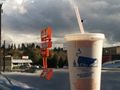
If I can't reach the hashpoint, at least I have milkshake. @47.8011,-122.3315
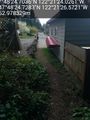
A close park exit... @47.8069,-122.3574
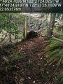
Another exit @47.8069,-122.3570


Achievements