Difference between revisions of "2015-05-08 52 1"
From Geohashing
imported>Sourcerer (→New Expedition) |
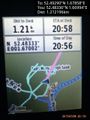
imported>Sourcerer m ([live picture] Closest I got. [http://www.openstreetmap.org/?lat=52.48336315&lon=1.66994333&zoom=16&layers=B000FTF @52.4834,1.6699]) |
||
| Line 21: | Line 21: | ||
<gallery perrow="5"> | <gallery perrow="5"> | ||
| + | |||
| + | Image:2015-05-08_52_1_Sourcerer_1431114982542.jpg | Closest I got. [http://www.openstreetmap.org/?lat=52.48336315&lon=1.66994333&zoom=16&layers=B000FTF @52.4834,1.6699] | ||
</gallery> | </gallery> | ||
Revision as of 19:57, 8 May 2015
| Fri 8 May 2015 in 52,1: 52.4928954, 1.6785815 geohashing.info google osm bing/os kml crox |
Location
In a grazing field on the marshes north east of the Waveney River Centre, Norfolk, UK.
Participants
Expedition
Still to be attempted ...
Photos
Closest I got. @52.4834,1.6699
