Difference between revisions of "2015-05-14 48 8"
From Geohashing
imported>RecentlyChanged (→Expedition) |
imported>RecentlyChanged |
||
| Line 63: | Line 63: | ||
<!-- Add any achievement ribbons you earned below, or remove this section --> | <!-- Add any achievement ribbons you earned below, or remove this section --> | ||
| − | |||
| − | |||
| − | |||
[[Category:New report]] | [[Category:New report]] | ||
| − | + | [[Category:Expeditions]] | |
| − | |||
| − | |||
| − | |||
| − | [[Category: | ||
| − | |||
| − | |||
| − | |||
| − | |||
[[Category:Expeditions with photos]] | [[Category:Expeditions with photos]] | ||
| − | + | ||
| − | |||
| − | |||
| − | |||
| − | |||
[[Category:Coordinates reached]] | [[Category:Coordinates reached]] | ||
| − | |||
| − | |||
| − | |||
| − | |||
| − | |||
| − | |||
| − | |||
| − | |||
| − | |||
| − | |||
| − | |||
| − | |||
| − | |||
| − | |||
| − | |||
| − | |||
| − | |||
| − | |||
Revision as of 16:57, 14 May 2015
| Thu 14 May 2015 in 48,8: 48.7934498, 8.2355887 geohashing.info google osm bing/os kml crox |
Location
Near Baden-Baden, Haueneberstein, forest.
Participants
Plans
Taking the S4 from Karlsruhe to Haueneberstein, walk and be back after about three hours. No special ideas this time, I have to be back in time!
Expedition
Took the train as planned, walked about one and a half hour. Rechable. The weather wasn't beautiful but it was warm and there was no rain.
Tracklog
Photos
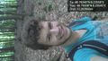
Stupid grin :) @48.7934,8.2355
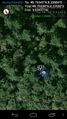
Proof @48.7934,8.2355
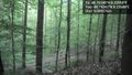
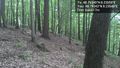
Northeast @48.7934,8.2355
North @48.7934,8.2355
West @48.7934,8.2355
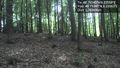
South @48.7934,8.2356
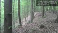
East. All in all: a beautiful place! @48.7935,8.2355
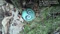
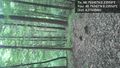
Marker... @48.7934,8.2355
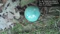
...with some text on it. @48.7934,8.2355


