Difference between revisions of "2015-05-17 48 8"
imported>Klaus |
imported>Klaus |
||
| Line 1: | Line 1: | ||
| − | |||
| − | [[Image:{{{image| | + | [[Image:{{{image|2015-05-17 48 8 geohash.jpg}}}|thumb|left]] |
| − | |||
| − | |||
| − | |||
| − | |||
| − | |||
{{meetup graticule | {{meetup graticule | ||
| lat=48 | | lat=48 | ||
| Line 50: | Line 44: | ||
== Tracklog == | == Tracklog == | ||
| − | + | As I didn't figure out how to upload GPX, see the image down there :) | |
== Photos == | == Photos == | ||
| Line 60: | Line 54: | ||
Image:2015-05-17 48 8 geohash.jpg | Around 8 metres in this field was the geohash | Image:2015-05-17 48 8 geohash.jpg | Around 8 metres in this field was the geohash | ||
Image:2015-05-17 48 8 weilheim.jpg | The village fair in Weilheim, where I stopped for a short break | Image:2015-05-17 48 8 weilheim.jpg | The village fair in Weilheim, where I stopped for a short break | ||
| + | Image:2015-05-17 48 8 track.png | My Tracklog as image | ||
</gallery> | </gallery> | ||
Revision as of 20:25, 17 May 2015

| Sun 17 May 2015 in 48,8: 48.4769379, 8.8741651 geohashing.info google osm bing/os kml crox |
Location
on a field near Neustetten/Rottenburg
Participants
Plans
This one seems easy enough and I have some free time, so Klaus will attempt his first geohash from Tuebingen by starting with his bicycle around 2pm ;)
Expedition
Klaus
I started at around 1:50pm from my home.
It was quite an easy bike ride until Rottenburg, with very good, flat and paved bicyle roads. After Rottenburg, I had to get up a little hill to the get to the village of Neustetten which is ~100hm above Rottenburg.
I was at the nearest point to the geohash where I could go without destroying the crops on the field which were already quite high. The next I was to the geohash was around 8 metres. So hopefully this counts as this was my first one :)
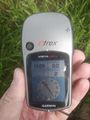
The route back was a little different one. I got a little lost in the unpaved farm lanes between the fields. They always got worse, and I even had to push my bicycle a few hundred meters, as I couldn't drive anymore. Note to myself: For the next geohash I attempt, I'll download the OSM map to my Garmin eTrex Vista first, so I can see where the paved roads are :)
On the route back I stopped in Weilheim, as there was a little village fair. I ate a pair of bratwurst and drank some "Radler". (Funny note for non-Germans: "Radler" is a German word which can mean either "bicyclist" and "beer with sprite")
I arrived at home around 17:00. All in all it was nice and sunny 42km bicycle tour.
Tracklog
As I didn't figure out how to upload GPX, see the image down there :)
Photos
Proof
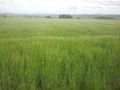
Around 8 metres in this field was the geohash
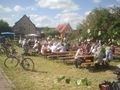
The village fair in Weilheim, where I stopped for a short break
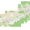
My Tracklog as image


