Difference between revisions of "2015-05-24 45 -75"
From Geohashing
imported>Jlam (→Location) |
imported>Jlam (→Achievements) |
||
| Line 56: | Line 56: | ||
<!-- Add any achievement ribbons you earned below, or remove this section --> | <!-- Add any achievement ribbons you earned below, or remove this section --> | ||
| − | |||
| − | |||
| − | |||
| − | |||
| − | |||
| − | |||
| − | |||
| − | |||
| − | |||
| − | |||
| − | |||
| − | |||
| − | |||
[[Category:Expeditions]] | [[Category:Expeditions]] | ||
| − | |||
[[Category:Expeditions with photos]] | [[Category:Expeditions with photos]] | ||
| − | |||
| − | |||
| − | |||
| − | |||
| − | |||
[[Category:Coordinates reached]] | [[Category:Coordinates reached]] | ||
| + | {{bicycle geohash | ||
| − | - | + | | latitude = 45.4497 |
| − | + | | longitude = -75.6775 | |
| − | + | | date = 2015-05-24 | |
| − | + | | name = jlam | |
| − | + | | distance = 22 | |
| − | + | | bothways = true | |
| − | + | | image = 2015-05-24_45_-75_jlam_1432501728891.jpg | |
| − | |||
| − | |||
| − | |||
| − | |||
| − | |||
| − | |||
| − | |||
| − | + | }} | |
Revision as of 01:35, 25 May 2015
| Sun 24 May 2015 in 45,-75: 45.4497151, -75.6774815 geohashing.info google osm bing/os kml crox |
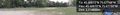
Location
Running track of Rockcliffe Park Public School
Participants
Plans
Expedition
- Geohash was in Rockliffe Manor park today. Good excuse for a half hour bike ride. Had to wait until the muggles cleared the park. To bad I didn't have a "The internet was here" poster. -- Jlam (talk) @45.4497,-75.6775 17:17, 24 May 2015 (EDT)
Tracklog
Photos
Nice bikeride to geohash in Rockcliffe park @45.4497,-75.6775
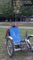
Nice ride to geogash in Rockcliffe park @45.4497,-75.6775
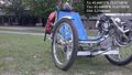
Nice ride to geohasg in Rocklife park. Quite the fancy houses here! @45.4497,-75.6775


Achievements
jlam earned the Bicycle geohash achievement
|