Difference between revisions of "2015-05-29 47 -122"
From Geohashing
imported>Thomcat ([live picture] [http://www.openstreetmap.org/?lat=47.80776316&lon=-122.25178253&zoom=16&layers=B000FTF @47.8078,-122.2518]) |
imported>Thomcat ([live] On the spot) |
||
| Line 20: | Line 20: | ||
<!-- how it all turned out. your narrative goes here. --> | <!-- how it all turned out. your narrative goes here. --> | ||
| + | |||
| + | *On the spot -- [[User:Thomcat|Thomcat]] ([[User talk:Thomcat|talk]]) [http://www.openstreetmap.org/?lat=47.80781280&lon=-122.25190134&zoom=16&layers=B000FTF @47.8078,-122.2519] 12:45, 29 May 2015 (PDT) | ||
== Tracklog == | == Tracklog == | ||
<!-- if your GPS device keeps a log, you may post a link here --> | <!-- if your GPS device keeps a log, you may post a link here --> | ||
Revision as of 19:45, 29 May 2015
| Fri 29 May 2015 in Seattle: 47.8078270, -122.2518924 geohashing.info google osm bing/os kml crox |
Location
The corner of Logan Park, in the Alderwood Manor neighborhood.
Participants
Plans
Visit at lunchtime if I haven't heard from anyone else.
Expedition
- On the spot -- Thomcat (talk) @47.8078,-122.2519 12:45, 29 May 2015 (PDT)
Tracklog
Photos
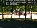
Playground @47.8083,-122.2525


Achievements