Difference between revisions of "2015-06-02 52 5"
From Geohashing
imported>Chrunchstick |
imported>Sourcerer m (→removed new report category) |
||
| Line 55: | Line 55: | ||
<!-- =============== USEFUL CATEGORIES FOLLOW ================ | <!-- =============== USEFUL CATEGORIES FOLLOW ================ | ||
Delete the next line ONLY if you have chosen the appropriate categories below. If you are unsure, don't worry. People will read your report and help you with the classification.--> | Delete the next line ONLY if you have chosen the appropriate categories below. If you are unsure, don't worry. People will read your report and help you with the classification.--> | ||
| − | |||
<!-- ==REQUEST FOR TWITTER BOT== Please leave either the New report or the Expedition planning category in as long as you work on it. This helps the twitter bot a lot with announcing the right outcome at the right moment. --> | <!-- ==REQUEST FOR TWITTER BOT== Please leave either the New report or the Expedition planning category in as long as you work on it. This helps the twitter bot a lot with announcing the right outcome at the right moment. --> | ||
| − | |||
| − | |||
[[Category:Expeditions]] | [[Category:Expeditions]] | ||
[[Category:Expeditions with photos]] | [[Category:Expeditions with photos]] | ||
[[Category:Coordinates reached]] | [[Category:Coordinates reached]] | ||
Revision as of 13:51, 25 July 2015
| Tue 2 Jun 2015 in Utrecht, Netherlands: 52.3622358, 5.2662186 geohashing.info google osm bing/os kml crox |
Location
A gully in Almere Danswijk
Participants
Plans
First time geohashing, not expecting anyone to be there. Just checking it out between 13:00 - 14:30.
Expedition
So I got there by public transport from Amersfoort. I took to train to Hilversum and Almere C. Bus line 6 took me to about 600 meters from the Geohash. Arriving at the location there where no other Geohashers present, however it was worth discovering some new territory nearby.
Tracklog
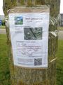
Photos
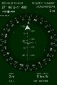
Location/date/time data.
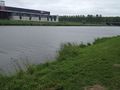
The gully

Stupid Grin
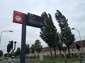
Waiting for the bus
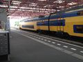
Waiting for the train
The Tag


